
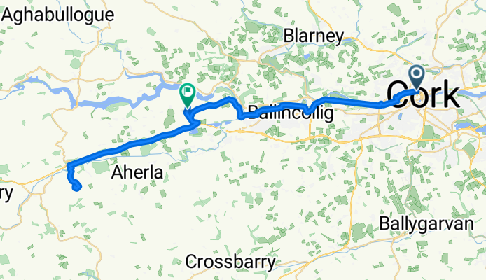
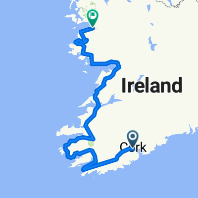
Route from MacCurtain Street 33/34
A cycling route starting in Cork, Munster, Ireland.
Overview
About this route
- 1 h 47 min
- Duration
- 44.4 km
- Distance
- 283 m
- Ascent
- 279 m
- Descent
- 24.9 km/h
- Avg. speed
- 152 m
- Max. altitude

Route photos


Continue with Bikemap
Use, edit, or download this cycling route
You would like to ride Route from MacCurtain Street 33/34 or customize it for your own trip? Here is what you can do with this Bikemap route:
Free features
- Save this route as favorite or in collections
- Copy & plan your own version of this route
- Sync your route with Garmin or Wahoo
Premium features
Free trial for 3 days, or one-time payment. More about Bikemap Premium.
- Navigate this route on iOS & Android
- Export a GPX / KML file of this route
- Create your custom printout (try it for free)
- Download this route for offline navigation
Discover more Premium features.
Get Bikemap PremiumFrom our community
Other popular routes starting in Cork
 Irland Südrunde 1700
- Distance
- 1,659.9 km
- Ascent
- 896 m
- Descent
- 896 m
- Location
- Cork, Munster, Ireland
 Route from 23–99 North Mall, Cork
- Distance
- 21.9 km
- Ascent
- 0 m
- Descent
- 73 m
- Location
- Cork, Munster, Ireland
 Lengthy bike tour from Cork to Kinsale
- Distance
- 30.2 km
- Ascent
- 351 m
- Descent
- 342 m
- Location
- Cork, Munster, Ireland
 Short Evening Route
- Distance
- 31.6 km
- Ascent
- 353 m
- Descent
- 277 m
- Location
- Cork, Munster, Ireland
 Cork - Oysterhaven/sea & back
- Distance
- 77.2 km
- Ascent
- 751 m
- Descent
- 751 m
- Location
- Cork, Munster, Ireland
 Tag 27: Irland Niemandsland
- Distance
- 94 km
- Ascent
- 1,205 m
- Descent
- 1,148 m
- Location
- Cork, Munster, Ireland
 wc18_180112
- Distance
- 701.3 km
- Ascent
- 1,244 m
- Descent
- 1,239 m
- Location
- Cork, Munster, Ireland
 cork harbour via Carrigaline
- Distance
- 29.6 km
- Ascent
- 16 m
- Descent
- 73 m
- Location
- Cork, Munster, Ireland
Open it in the app