
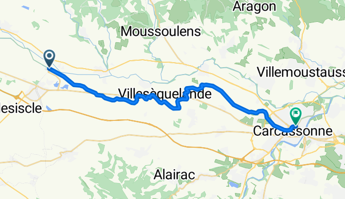
Bram / Carcassonne
A cycling route starting in Bram, Occitanie, France.
Overview
About this route
- 3 h 50 min
- Duration
- 24.1 km
- Distance
- 18 m
- Ascent
- 30 m
- Descent
- 6.3 km/h
- Avg. speed
- 133 m
- Max. altitude
Continue with Bikemap
Use, edit, or download this cycling route
You would like to ride Bram / Carcassonne or customize it for your own trip? Here is what you can do with this Bikemap route:
Free features
- Save this route as favorite or in collections
- Copy & plan your own version of this route
- Sync your route with Garmin or Wahoo
Premium features
Free trial for 3 days, or one-time payment. More about Bikemap Premium.
- Navigate this route on iOS & Android
- Export a GPX / KML file of this route
- Create your custom printout (try it for free)
- Download this route for offline navigation
Discover more Premium features.
Get Bikemap PremiumFrom our community
Other popular routes starting in Bram
 Bram - Narbone
- Distance
- 254.2 km
- Ascent
- 2,350 m
- Descent
- 2,468 m
- Location
- Bram, Occitanie, France
 étape 6 Bram - Homps vendredi 25
- Distance
- 67.7 km
- Ascent
- 185 m
- Descent
- 271 m
- Location
- Bram, Occitanie, France
 2013 Ride Day 25 - Bram Circle through Labécède-Lauragais and Lasbordes
- Distance
- 52.9 km
- Ascent
- 447 m
- Descent
- 444 m
- Location
- Bram, Occitanie, France
 2013 Ride Day 26 - Bram Circle through Laurac and Cazalrenoux
- Distance
- 47.5 km
- Ascent
- 385 m
- Descent
- 385 m
- Location
- Bram, Occitanie, France
 Bram > Andorra-Pal (203 km)
- Distance
- 202.9 km
- Ascent
- 4,433 m
- Descent
- 2,678 m
- Location
- Bram, Occitanie, France
 Day 38 | Bram to Puichéric
- Distance
- 71.2 km
- Ascent
- 91 m
- Descent
- 201 m
- Location
- Bram, Occitanie, France
 De À Fresquel 942, Bram à Rue du Pourtanel 8, Pexiora
- Distance
- 10.4 km
- Ascent
- 20 m
- Descent
- 56 m
- Location
- Bram, Occitanie, France
 2013 Ride Day 28 - Bram to St-Pierre-de-Rivière (Foix)
- Distance
- 90 km
- Ascent
- 1,033 m
- Descent
- 707 m
- Location
- Bram, Occitanie, France
Open it in the app