
Sasbach - Plochingen
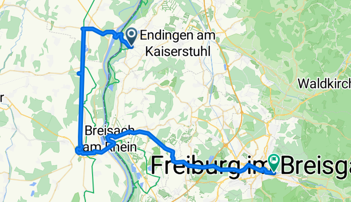
Sasbach - Freiburg
A cycling route starting in Sasbach, Baden-Wurttemberg, Germany.
Overview
About this route
- 3 h 51 min
- Duration
- 61.7 km
- Distance
- 293 m
- Ascent
- 180 m
- Descent
- 16 km/h
- Avg. speed
- 294 m
- Max. altitude

Part of
Sasbach - Plochingen
5 stages
Route quality
Waytypes & surfaces along the route
Waytypes
Track
19.7 km
(32 %)
Path
14.8 km
(24 %)
Surfaces
Paved
39.5 km
(64 %)
Unpaved
14.2 km
(23 %)
Asphalt
35.8 km
(58 %)
Loose gravel
8.6 km
(14 %)
Route highlights
Points of interest along the route
Point of interest after 24.1 km
Point of interest after 31.7 km
Point of interest after 31.9 km
Point of interest after 31.9 km
Point of interest after 32 km
Point of interest after 32.2 km
Point of interest after 32.4 km
Point of interest after 50.9 km
Pillboxes Maginot Linie
Point of interest after 59.1 km
Point of interest after 59.1 km
Point of interest after 59.3 km
Point of interest after 59.5 km
Point of interest after 59.7 km
Drinking water after 59.8 km
Drinking water after 59.9 km
Drinking water after 59.9 km
Point of interest after 60 km
Point of interest after 60.4 km
Continue with Bikemap
Use, edit, or download this cycling route
You would like to ride Sasbach - Freiburg or customize it for your own trip? Here is what you can do with this Bikemap route:
Free features
- Save this route as favorite or in collections
- Copy & plan your own version of this route
- Sync your route with Garmin or Wahoo
Premium features
Free trial for 3 days, or one-time payment. More about Bikemap Premium.
- Navigate this route on iOS & Android
- Export a GPX / KML file of this route
- Create your custom printout (try it for free)
- Download this route for offline navigation
Discover more Premium features.
Get Bikemap PremiumFrom our community
Other popular routes starting in Sasbach
 zum Totenkopf hinauf
- Distance
- 39.7 km
- Ascent
- 473 m
- Descent
- 472 m
- Location
- Sasbach, Baden-Wurttemberg, Germany
 Prächtige Audienz am Kaiserstuhl
- Distance
- 99.7 km
- Ascent
- 730 m
- Descent
- 731 m
- Location
- Sasbach, Baden-Wurttemberg, Germany
 Quer durch die Weinberge und den Auwald
- Distance
- 28.4 km
- Ascent
- 375 m
- Descent
- 377 m
- Location
- Sasbach, Baden-Wurttemberg, Germany
 Rund um den Kaiserstuhl
- Distance
- 63.2 km
- Ascent
- 172 m
- Descent
- 170 m
- Location
- Sasbach, Baden-Wurttemberg, Germany
 Jechtingen-Le Grand Ballon-Munster-Colmar
- Distance
- 157.6 km
- Ascent
- 1,185 m
- Descent
- 1,185 m
- Location
- Sasbach, Baden-Wurttemberg, Germany
 Porýní
- Distance
- 58.2 km
- Ascent
- 48 m
- Descent
- 48 m
- Location
- Sasbach, Baden-Wurttemberg, Germany
 Eichstetten, Vogtsburg, Bischoffingen
- Distance
- 32.3 km
- Ascent
- 433 m
- Descent
- 419 m
- Location
- Sasbach, Baden-Wurttemberg, Germany
 Über den Totenkopf nach Breisach...
- Distance
- 51.5 km
- Ascent
- 502 m
- Descent
- 482 m
- Location
- Sasbach, Baden-Wurttemberg, Germany
Open it in the app