

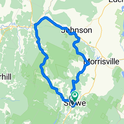
Route in Stowe
A cycling route starting in Morristown, Vermont, United States.
Overview
About this route
- 4 h 53 min
- Duration
- 71.5 km
- Distance
- 1,495 m
- Ascent
- 1,487 m
- Descent
- 14.6 km/h
- Avg. speed
- 695 m
- Max. altitude

Route quality
Waytypes & surfaces along the route
Waytypes
Quiet road
33.6 km
(47 %)
Cycleway
24.3 km
(34 %)
Surfaces
Paved
33.6 km
(47 %)
Unpaved
36.4 km
(51 %)
Asphalt
32.9 km
(46 %)
Gravel
21.4 km
(30 %)
Continue with Bikemap
Use, edit, or download this cycling route
You would like to ride Route in Stowe or customize it for your own trip? Here is what you can do with this Bikemap route:
Free features
- Save this route as favorite or in collections
- Copy & plan your own version of this route
- Sync your route with Garmin or Wahoo
Premium features
Free trial for 3 days, or one-time payment. More about Bikemap Premium.
- Navigate this route on iOS & Android
- Export a GPX / KML file of this route
- Create your custom printout (try it for free)
- Download this route for offline navigation
Discover more Premium features.
Get Bikemap PremiumFrom our community
Other popular routes starting in Morristown
 Notch route through Underhill
- Distance
- 101.9 km
- Ascent
- 1,033 m
- Descent
- 1,038 m
- Location
- Morristown, Vermont, United States
 Sterling Valley, Maple Run, Robinson Springs loop
- Distance
- 32.5 km
- Ascent
- 472 m
- Descent
- 472 m
- Location
- Morristown, Vermont, United States
 Stowe Gravel Send
- Distance
- 70.6 km
- Ascent
- 1,000 m
- Descent
- 1,005 m
- Location
- Morristown, Vermont, United States
 Sunset Rock + Hollow Rip
- Distance
- 12.4 km
- Ascent
- 309 m
- Descent
- 311 m
- Location
- Morristown, Vermont, United States
 Autour de Stowe
- Distance
- 98.8 km
- Ascent
- 512 m
- Descent
- 512 m
- Location
- Morristown, Vermont, United States
 Stowe_Capitol_Circuit_94km
- Distance
- 94.1 km
- Ascent
- 593 m
- Descent
- 592 m
- Location
- Morristown, Vermont, United States
 Stowe 50 Miler
- Distance
- 81.3 km
- Ascent
- 1,830 m
- Descent
- 1,824 m
- Location
- Morristown, Vermont, United States
 Route in Stowe
- Distance
- 71.5 km
- Ascent
- 1,495 m
- Descent
- 1,487 m
- Location
- Morristown, Vermont, United States
Open it in the app