
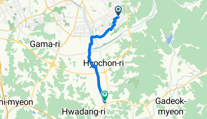
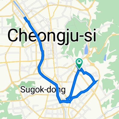
용암동, 청주시에서 고은리, 청주시까지
A cycling route starting in Cheongju-si, North Chungcheong, South Korea.
Overview
About this route
용암동 3148에서 고은리 460-10까지 자전거로 8.4km를 달리세요.
- 총 거리: 8.4km, 상승: 65m, 내리막: 109m
- 최대 고도: 113m
- 면적: 정의되지 않음
- 도로 유형: 자전거 도로 62.6%, 조용한 도로 32.7%
- 도로망: 지역 55.3%, 정의되지 않음 44.7%
이 코스는 용암동 3148에서 출발하여 청주시를 지나고, 고은리 460-10에 도착하는 8.4km의 도보 코스를 제공합니다. 이 코스는 자전거 도로와 조용한 도로로 구성되어 있으며, 총 62.6%의 구간이 자전거 도로입니다. 가장 높은 고도(113m)는 중간에 있는 고은리 460-10에 도달할 때 발생합니다.
- 29 min
- Duration
- 8.4 km
- Distance
- 66 m
- Ascent
- 110 m
- Descent
- 17.7 km/h
- Avg. speed
- 113 m
- Max. altitude

Route quality
Waytypes & surfaces along the route
Waytypes
Cycleway
5.2 km
(62 %)
Quiet road
2.8 km
(33 %)
Continue with Bikemap
Use, edit, or download this cycling route
You would like to ride 용암동, 청주시에서 고은리, 청주시까지 or customize it for your own trip? Here is what you can do with this Bikemap route:
Free features
- Save this route as favorite or in collections
- Copy & plan your own version of this route
- Sync your route with Garmin or Wahoo
Premium features
Free trial for 3 days, or one-time payment. More about Bikemap Premium.
- Navigate this route on iOS & Android
- Export a GPX / KML file of this route
- Create your custom printout (try it for free)
- Download this route for offline navigation
Discover more Premium features.
Get Bikemap PremiumFrom our community
Other popular routes starting in Cheongju-si
 사직동 95, 청주시 to 사직동 79, 청주시
- Distance
- 13.6 km
- Ascent
- 20 m
- Descent
- 21 m
- Location
- Cheongju-si, North Chungcheong, South Korea
 용암1동 771−104, 청주시 to 산성동 산28-2, 청주시
- Distance
- 9.7 km
- Ascent
- 602 m
- Descent
- 213 m
- Location
- Cheongju-si, North Chungcheong, South Korea
 금천동 312, 청주시 to 금천동 312, 청주시
- Distance
- 18.6 km
- Ascent
- 86 m
- Descent
- 88 m
- Location
- Cheongju-si, North Chungcheong, South Korea
 방서동 642-91, 청주시 ~ 25, 청주시
- Distance
- 6 km
- Ascent
- 42 m
- Descent
- 21 m
- Location
- Cheongju-si, North Chungcheong, South Korea
 충북자전거길 6-1_라이딩
- Distance
- 82 km
- Ascent
- 1,591 m
- Descent
- 1,591 m
- Location
- Cheongju-si, North Chungcheong, South Korea
 분평동 3, 청주시 to 용암동 770−41, 청주시
- Distance
- 68.5 km
- Ascent
- 957 m
- Descent
- 947 m
- Location
- Cheongju-si, North Chungcheong, South Korea
 2024 MTB 충북자전거종주길
- Distance
- 1,064.5 km
- Ascent
- 0 m
- Descent
- 0 m
- Location
- Cheongju-si, North Chungcheong, South Korea
 충북자전거길 6
- Distance
- 115.2 km
- Ascent
- 2,168 m
- Descent
- 2,169 m
- Location
- Cheongju-si, North Chungcheong, South Korea
Open it in the app