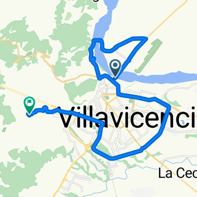
Ruta desde Villavicencio
A cycling route starting in Villavicencio, Meta Department, Colombia.
Overview
About this route
- 20 h 59 min
- Duration
- 784.4 km
- Distance
- 335 m
- Ascent
- 685 m
- Descent
- 37.4 km/h
- Avg. speed
- 425 m
- Max. altitude
Route photos
Continue with Bikemap
Use, edit, or download this cycling route
You would like to ride Ruta desde Villavicencio or customize it for your own trip? Here is what you can do with this Bikemap route:
Free features
- Save this route as favorite or in collections
- Copy & plan your own version of this route
- Split it into stages to create a multi-day tour
- Sync your route with Garmin or Wahoo
Premium features
Free trial for 3 days, or one-time payment. More about Bikemap Premium.
- Navigate this route on iOS & Android
- Export a GPX / KML file of this route
- Create your custom printout (try it for free)
- Download this route for offline navigation
Discover more Premium features.
Get Bikemap PremiumFrom our community
Other popular routes starting in Villavicencio
- Villavicencio - Pto López
- Distance
- 84.6 km
- Ascent
- 12 m
- Descent
- 315 m
- Location
- Villavicencio, Meta Department, Colombia
- 4.156, -73.632 a 4.271, -73.488
- Distance
- 23.5 km
- Ascent
- 147 m
- Descent
- 189 m
- Location
- Villavicencio, Meta Department, Colombia
- Ruta moderada en MTB
- Distance
- 11.1 km
- Ascent
- 115 m
- Descent
- 115 m
- Location
- Villavicencio, Meta Department, Colombia
- cumbre
- Distance
- 62.6 km
- Ascent
- 971 m
- Descent
- 963 m
- Location
- Villavicencio, Meta Department, Colombia
- Apiay, Villavicencio a VÃa Villavicencio - Puerto López, Villavicencio
- Distance
- 25.5 km
- Ascent
- 83 m
- Descent
- 84 m
- Location
- Villavicencio, Meta Department, Colombia
- 4.156, -73.632 a 4.138, -73.648
- Distance
- 25 km
- Ascent
- 467 m
- Descent
- 389 m
- Location
- Villavicencio, Meta Department, Colombia
- Ruta desde Villavicencio
- Distance
- 784.4 km
- Ascent
- 335 m
- Descent
- 685 m
- Location
- Villavicencio, Meta Department, Colombia
- buenavista X3
- Distance
- 48.8 km
- Ascent
- 2,303 m
- Descent
- 1,530 m
- Location
- Villavicencio, Meta Department, Colombia
Open it in the app