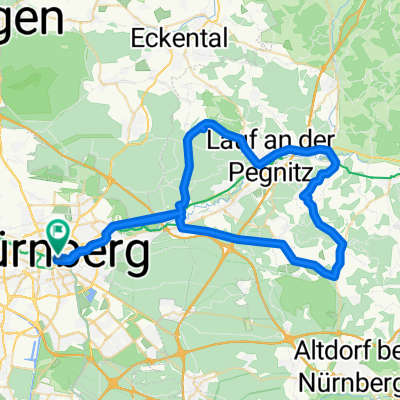
Overview
About this route
- 4 h 48 min
- Duration
- 82.5 km
- Distance
- 491 m
- Ascent
- 547 m
- Descent
- 17.2 km/h
- Avg. speed
- 480 m
- Max. altitude
Part of
Route in Nürnberg
4 stages
Route quality
Waytypes & surfaces along the route
Waytypes
Path
42.1 km
(51 %)
Track
19.8 km
(24 %)
Surfaces
Paved
67.6 km
(82 %)
Unpaved
5.8 km
(7 %)
Asphalt
64.3 km
(78 %)
Gravel
5.8 km
(7 %)
Continue with Bikemap
Use, edit, or download this cycling route
You would like to ride N4 - Dietfurt - Nürnberg or customize it for your own trip? Here is what you can do with this Bikemap route:
Free features
- Save this route as favorite or in collections
- Copy & plan your own version of this route
- Split it into stages to create a multi-day tour
- Sync your route with Garmin or Wahoo
Premium features
Free trial for 3 days, or one-time payment. More about Bikemap Premium.
- Navigate this route on iOS & Android
- Export a GPX / KML file of this route
- Create your custom printout (try it for free)
- Download this route for offline navigation
Discover more Premium features.
Get Bikemap PremiumFrom our community
Other popular routes starting in Dietfurt
W-05_Dietfurt-Regensburg_72km- Distance
- 71.7 km
- Ascent
- 457 m
- Descent
- 479 m
- Location
- Dietfurt, Bavaria, Germany
8. Etappe: Dietfurt – Altdorf (b. Landshut)- Distance
- 89.8 km
- Ascent
- 332 m
- Descent
- 302 m
- Location
- Dietfurt, Bavaria, Germany
Dietfurt - Regensburg- Distance
- 74.2 km
- Ascent
- 279 m
- Descent
- 314 m
- Location
- Dietfurt, Bavaria, Germany
Von Dietfurt an der Altmühl bis Riedenburg- Distance
- 17.1 km
- Ascent
- 237 m
- Descent
- 252 m
- Location
- Dietfurt, Bavaria, Germany
Altmühl 2- Distance
- 166.4 km
- Ascent
- 1,735 m
- Descent
- 1,759 m
- Location
- Dietfurt, Bavaria, Germany
Beilngrieser Straße 14, Dietfurt nach Ingolstadt- Distance
- 45.5 km
- Ascent
- 427 m
- Descent
- 424 m
- Location
- Dietfurt, Bavaria, Germany
Tulpenweg nach An der Altmühl- Distance
- 18.6 km
- Ascent
- 37 m
- Descent
- 60 m
- Location
- Dietfurt, Bavaria, Germany
Die Eichelberg-Acht- Distance
- 14.5 km
- Ascent
- 204 m
- Descent
- 204 m
- Location
- Dietfurt, Bavaria, Germany
Open it in the app


