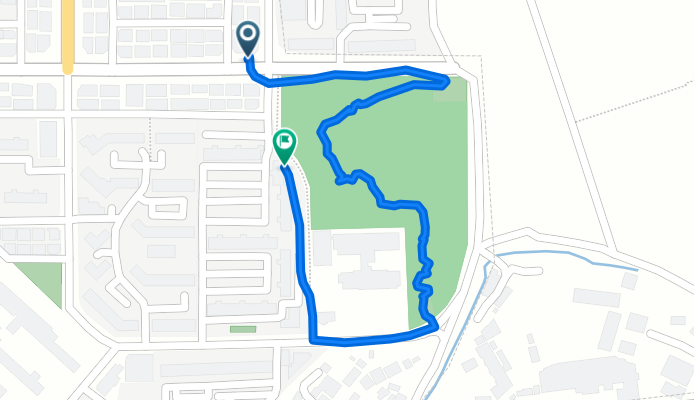
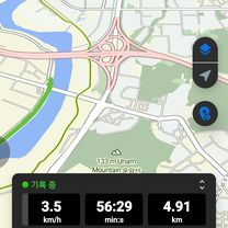
신가동 992-1 ~ 대한민국
A cycling route starting in Gwangju, Gwangju, South Korea.
Overview
About this route
- 32 min
- Duration
- 1.4 km
- Distance
- 89 m
- Ascent
- 114 m
- Descent
- 2.8 km/h
- Avg. speed
- 66 m
- Max. altitude
Route photos
Continue with Bikemap
Use, edit, or download this cycling route
You would like to ride 신가동 992-1 ~ 대한민국 or customize it for your own trip? Here is what you can do with this Bikemap route:
Free features
- Save this route as favorite or in collections
- Copy & plan your own version of this route
- Sync your route with Garmin or Wahoo
Premium features
Free trial for 3 days, or one-time payment. More about Bikemap Premium.
- Navigate this route on iOS & Android
- Export a GPX / KML file of this route
- Create your custom printout (try it for free)
- Download this route for offline navigation
Discover more Premium features.
Get Bikemap PremiumFrom our community
Other popular routes starting in Gwangju
- 서석동 422-17 ~ 서석동 422-16
- Distance
- 20.6 km
- Ascent
- 60 m
- Descent
- 86 m
- Location
- Gwangju, Gwangju, South Korea
- 신용동, 광주광역시에서 마륵동, 광주광역시까지
- Distance
- 11.2 km
- Ascent
- 11 m
- Descent
- 19 m
- Location
- Gwangju, Gwangju, South Korea
- Gwangju 50km circuit
- Distance
- 52.9 km
- Ascent
- 257 m
- Descent
- 256 m
- Location
- Gwangju, Gwangju, South Korea
- Ph0]에서 경로봉산면 1197-7
- Distance
- 5.7 km
- Ascent
- 18 m
- Descent
- 29 m
- Location
- Gwangju, Gwangju, South Korea
- 신가동 992-1 ~ 대한민국
- Distance
- 1.4 km
- Ascent
- 89 m
- Descent
- 114 m
- Location
- Gwangju, Gwangju, South Korea
- 광주천 라읻
- Distance
- 44.4 km
- Ascent
- 110 m
- Descent
- 119 m
- Location
- Gwangju, Gwangju, South Korea
- 편안한 경로
- Distance
- 5.2 km
- Ascent
- 13 m
- Descent
- 24 m
- Location
- Gwangju, Gwangju, South Korea
- Ph0]에서 경로담양읍 125-1
- Distance
- 20.3 km
- Ascent
- 61 m
- Descent
- 111 m
- Location
- Gwangju, Gwangju, South Korea
Open it in the app