![Ph0]에서 경로양서면](/_next/static/media/contour-lines-light-small.cafd5e5d.avif)
![Ph0]에서 경로양서면](https://media.bikemap.net/routes/17638240/staticmaps/in_5c888c24-e78c-41ce-bf94-d5ee0eb3462b_694x400_bikemap-2021-3D-static.png)
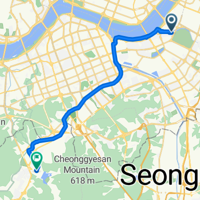
Ph0]에서 경로양서면
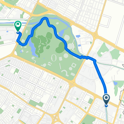
A cycling route starting in Hanam, Gyeonggi-do, South Korea.
Overview
About this route
- 3 h 44 min
- Duration
- 35.1 km
- Distance
- 143 m
- Ascent
- 160 m
- Descent
- 9.4 km/h
- Avg. speed
- 65 m
- Max. altitude

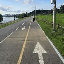
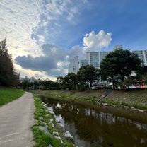
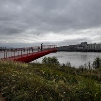
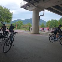
Route photos
![Photo 1 of the Bikemap route "Ph0]에서 경로양서면"](https://media.bikemap.net/routes/17638240/gallery/thumbs/8494bba0-b649-4e06-920a-fa8b786083ac.jpg.688x400_q80_crop.jpg "Photo 1 of the Bikemap route \"Ph0]에서 경로양서면\"")
![Photo 2 of the Bikemap route "Ph0]에서 경로양서면"](https://media.bikemap.net/routes/17638240/gallery/thumbs/b41d98b3-55f3-40b0-968f-c04aafac2cbd.jpg.688x400_q80_crop.jpg "Photo 2 of the Bikemap route \"Ph0]에서 경로양서면\"")
![Photo 3 of the Bikemap route "Ph0]에서 경로양서면"](https://media.bikemap.net/routes/17638240/gallery/thumbs/323b0479-a13b-4d3e-a312-5848b1a91045.jpg.208x208_q80_crop.jpg "Photo 3 of the Bikemap route \"Ph0]에서 경로양서면\"")
![Photo 4 of the Bikemap route "Ph0]에서 경로양서면"](https://media.bikemap.net/routes/17638240/gallery/thumbs/fbec8acb-a614-40e1-afa1-8a724104fdb7.jpg.208x208_q80_crop.jpg "Photo 4 of the Bikemap route \"Ph0]에서 경로양서면\"")
![Photo 5 of the Bikemap route "Ph0]에서 경로양서면"](https://media.bikemap.net/routes/17638240/gallery/thumbs/f8bc81cf-bbda-4b7a-9505-ae033e4bd7d7.jpg.208x208_q80_crop.jpg "Photo 5 of the Bikemap route \"Ph0]에서 경로양서면\"")
Continue with Bikemap
Use, edit, or download this cycling route
You would like to ride Ph0]에서 경로양서면 or customize it for your own trip? Here is what you can do with this Bikemap route:
Free features
- Save this route as favorite or in collections
- Copy & plan your own version of this route
- Sync your route with Garmin or Wahoo
Premium features
Free trial for 3 days, or one-time payment. More about Bikemap Premium.
- Navigate this route on iOS & Android
- Export a GPX / KML file of this route
- Create your custom printout (try it for free)
- Download this route for offline navigation
Discover more Premium features.
Get Bikemap PremiumFrom our community
Other popular routes starting in Hanam
 동남로29길, 서울특별시에서 신천동, 서울특별시까지
- Distance
- 4.4 km
- Ascent
- 24 m
- Descent
- 24 m
- Location
- Hanam, Gyeonggi-do, South Korea
![Ph0]에서 경로양서면](https://media.bikemap.net/routes/17638240/gallery/thumbs/8494bba0-b649-4e06-920a-fa8b786083ac.jpg.208x208_q80_crop.jpg) Ph0]에서 경로양서면
Ph0]에서 경로양서면- Distance
- 35.1 km
- Ascent
- 143 m
- Descent
- 160 m
- Location
- Hanam, Gyeonggi-do, South Korea
 인덕원 팔당
- Distance
- 47.1 km
- Ascent
- 274 m
- Descent
- 270 m
- Location
- Hanam, Gyeonggi-do, South Korea
 창우동, 하남시에서 덕풍동, 하남시까지
- Distance
- 5.7 km
- Ascent
- 109 m
- Descent
- 110 m
- Location
- Hanam, Gyeonggi-do, South Korea
 신천동, 서울특별시에서 신천동, 서울특별시까지
- Distance
- 28.4 km
- Ascent
- 190 m
- Descent
- 222 m
- Location
- Hanam, Gyeonggi-do, South Korea
 신천동, 서울특별시에서 막계동, 과천시까지
- Distance
- 19.5 km
- Ascent
- 73 m
- Descent
- 44 m
- Location
- Hanam, Gyeonggi-do, South Korea
 미사동 3-23 ~ 미사동 567-4
- Distance
- 8.5 km
- Ascent
- 44 m
- Descent
- 38 m
- Location
- Hanam, Gyeonggi-do, South Korea
 신천동, 서울특별시에서 신천동, 서울특별시까지
- Distance
- 35.1 km
- Ascent
- 159 m
- Descent
- 164 m
- Location
- Hanam, Gyeonggi-do, South Korea
Open it in the app