
COL DE L'ESPINOSE (por Poujouls-sur-Orb)
A cycling route starting in Le Poujol-sur-Orb, Occitanie, France.
Overview
About this route
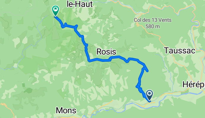
The Col de l'Espinouse, at 1,116 metres altitude, is one of the most representative passes of the massif that bears its name in the French Languedoc. Its ascent from Poujouls-sur-Orb, covering 21.8 kilometres, 944 metres of accumulated elevation gain and an average gradient of 4.3%, is characterised by being a long, gentle and very regular climb, where pacing is more important than power spikes.
- 1 h 28 min
- Duration
- 21.1 km
- Distance
- 1,419 m
- Ascent
- 465 m
- Descent
- 14.4 km/h
- Avg. speed
- 1,124 m
- Max. altitude

Route photos
\"")
Route quality
Waytypes & surfaces along the route
Waytypes
Road
21.1 km
(100 %)
Continue with Bikemap
Use, edit, or download this cycling route
You would like to ride COL DE L'ESPINOSE (por Poujouls-sur-Orb) or customize it for your own trip? Here is what you can do with this Bikemap route:
Free features
- Save this route as favorite or in collections
- Copy & plan your own version of this route
- Sync your route with Garmin or Wahoo
Premium features
Free trial for 3 days, or one-time payment. More about Bikemap Premium.
- Navigate this route on iOS & Android
- Export a GPX / KML file of this route
- Create your custom printout (try it for free)
- Download this route for offline navigation
Discover more Premium features.
Get Bikemap PremiumFrom our community
Other popular routes starting in Le Poujol-sur-Orb
 Portée de l'Espinouse
- Distance
- 84.1 km
- Ascent
- 1,433 m
- Descent
- 1,433 m
- Location
- Le Poujol-sur-Orb, Occitanie, France
 france 2009-10 olargues-béziers
- Distance
- 62 km
- Ascent
- 348 m
- Descent
- 666 m
- Location
- Le Poujol-sur-Orb, Occitanie, France
 ESPINOUSSE FONTFROIDE
- Distance
- 98.2 km
- Ascent
- 1,392 m
- Descent
- 1,392 m
- Location
- Le Poujol-sur-Orb, Occitanie, France
 Vio_20151206_Orb_Sud
- Distance
- 126.1 km
- Ascent
- 1,712 m
- Descent
- 1,711 m
- Location
- Le Poujol-sur-Orb, Occitanie, France
 Etappe 02 Olargues - Saint Amans Soult
- Distance
- 42.8 km
- Ascent
- 393 m
- Descent
- 303 m
- Location
- Le Poujol-sur-Orb, Occitanie, France
 2019 Bahntrasse Massamet-Herepian
- Distance
- 14.2 km
- Ascent
- 143 m
- Descent
- 154 m
- Location
- Le Poujol-sur-Orb, Occitanie, France
 Étape 4 : option Lac Salagou
- Distance
- 36.2 km
- Ascent
- 363 m
- Descent
- 397 m
- Location
- Le Poujol-sur-Orb, Occitanie, France
 Vio_20151205_Orb_Nord
- Distance
- 109.5 km
- Ascent
- 1,961 m
- Descent
- 1,961 m
- Location
- Le Poujol-sur-Orb, Occitanie, France
Open it in the app