
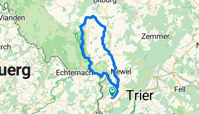
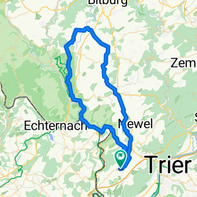
60km Prümzurlay - Burg
A cycling route starting in Trierweiler, Rhineland-Palatinate, Germany.
Overview
About this route
Embark on a scenic cycling adventure through the picturesque landscapes of Rhineland-Palatinate. Begin your journey in Koppbach 16, Trierweiler, and pedal your way through charming villages and lush forests. As you ride, enjoy the diverse terrain that includes both paved and unpaved paths. The route is predominantly paved, making it suitable for all skill levels. Feel the thrill of cycling along tranquil routes interspersed with serene forest trails, offering stunning views and a peaceful atmosphere. The ascent of 1130 meters and descent of 1129 meters promise a dynamic ride, with the highest point reaching 405 meters. This 59.5 km route is perfect for those seeking a blend of challenge and tranquility.
- 3 h 39 min
- Duration
- 59.5 km
- Distance
- 1,131 m
- Ascent
- 1,129 m
- Descent
- 16.3 km/h
- Avg. speed
- 405 m
- Max. altitude

Route quality
Waytypes & surfaces along the route
Waytypes
Track
20.8 km
(35 %)
Road
14.9 km
(25 %)
Surfaces
Paved
27.9 km
(47 %)
Unpaved
11.3 km
(19 %)
Asphalt
21.4 km
(36 %)
Paved (undefined)
6.5 km
(11 %)
Continue with Bikemap
Use, edit, or download this cycling route
You would like to ride 60km Prümzurlay - Burg or customize it for your own trip? Here is what you can do with this Bikemap route:
Free features
- Save this route as favorite or in collections
- Copy & plan your own version of this route
- Sync your route with Garmin or Wahoo
Premium features
Free trial for 3 days, or one-time payment. More about Bikemap Premium.
- Navigate this route on iOS & Android
- Export a GPX / KML file of this route
- Create your custom printout (try it for free)
- Download this route for offline navigation
Discover more Premium features.
Get Bikemap PremiumFrom our community
Other popular routes starting in Trierweiler
 SS 16+18 - Sauertal
- Distance
- 14.8 km
- Ascent
- 328 m
- Descent
- 316 m
- Location
- Trierweiler, Rhineland-Palatinate, Germany
 2023-06-23-9 Burer Millen-Hauptstrasse 84, Gerolstein
- Distance
- 68.4 km
- Ascent
- 985 m
- Descent
- 775 m
- Location
- Trierweiler, Rhineland-Palatinate, Germany
 Born Untereisenbach
- Distance
- 58.3 km
- Ascent
- 317 m
- Descent
- 214 m
- Location
- Trierweiler, Rhineland-Palatinate, Germany
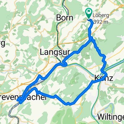 Trierweiler - Konz - Tawern - Grevenmacher - Trierweiler
- Distance
- 39.1 km
- Ascent
- 665 m
- Descent
- 662 m
- Location
- Trierweiler, Rhineland-Palatinate, Germany
 60km Prümzurlay - Burg
- Distance
- 59.5 km
- Ascent
- 1,131 m
- Descent
- 1,129 m
- Location
- Trierweiler, Rhineland-Palatinate, Germany
 Bergtraining
- Distance
- 4.6 km
- Ascent
- 131 m
- Descent
- 131 m
- Location
- Trierweiler, Rhineland-Palatinate, Germany
 Trierweiler - Biewer - Wintersdorf
- Distance
- 53.8 km
- Ascent
- 500 m
- Descent
- 500 m
- Location
- Trierweiler, Rhineland-Palatinate, Germany
 Around Kersch - MTB
- Distance
- 33.5 km
- Ascent
- 463 m
- Descent
- 462 m
- Location
- Trierweiler, Rhineland-Palatinate, Germany
Open it in the app