
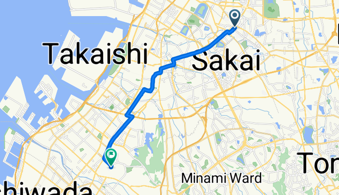
長曽根町, 堺市へ府中町5丁目, 和泉市
A cycling route starting in Matsubara, Osaka, Japan.
Overview
About this route
- 52 min
- Duration
- 12.7 km
- Distance
- 225 m
- Ascent
- 224 m
- Descent
- 14.7 km/h
- Avg. speed
- 32 m
- Max. altitude
Route quality
Waytypes & surfaces along the route
Waytypes
Pedestrian area
3.3 km
(26 %)
Quiet road
3.2 km
(25 %)
Surfaces
Paved
6.2 km
(49 %)
Asphalt
5.3 km
(42 %)
Paved (undefined)
0.9 km
(7 %)
Undefined
6.5 km
(51 %)
Continue with Bikemap
Use, edit, or download this cycling route
You would like to ride 長曽根町, 堺市へ府中町5丁目, 和泉市 or customize it for your own trip? Here is what you can do with this Bikemap route:
Free features
- Save this route as favorite or in collections
- Copy & plan your own version of this route
- Sync your route with Garmin or Wahoo
Premium features
Free trial for 3 days, or one-time payment. More about Bikemap Premium.
- Navigate this route on iOS & Android
- Export a GPX / KML file of this route
- Create your custom printout (try it for free)
- Download this route for offline navigation
Discover more Premium features.
Get Bikemap PremiumFrom our community
Other popular routes starting in Matsubara
 ツール・ド・堺 40kmコース逆走版
- Distance
- 27.9 km
- Ascent
- 409 m
- Descent
- 406 m
- Location
- Matsubara, Osaka, Japan
 1 - sakai to Himeji
- Distance
- 117 km
- Ascent
- 194 m
- Descent
- 120 m
- Location
- Matsubara, Osaka, Japan
 ツール・ド・堺
- Distance
- 87.5 km
- Ascent
- 575 m
- Descent
- 575 m
- Location
- Matsubara, Osaka, Japan
 ツール・ド・堺 100kmコース
- Distance
- 93.1 km
- Ascent
- 742 m
- Descent
- 743 m
- Location
- Matsubara, Osaka, Japan
 6-17, Karita 9-Chōme, Sumiyoshi, Osaka to 17-28, Daisennakamachi, Sakai, Sakai
- Distance
- 16.2 km
- Ascent
- 32 m
- Descent
- 40 m
- Location
- Matsubara, Osaka, Japan
 ツール・ド・堺 50kmコース逆走版
- Distance
- 49.5 km
- Ascent
- 756 m
- Descent
- 744 m
- Location
- Matsubara, Osaka, Japan
 Japan 2023 Southtrip
- Distance
- 1,671.6 km
- Ascent
- 17,133 m
- Descent
- 17,132 m
- Location
- Matsubara, Osaka, Japan
 128, Kanaokacho, Kita, Sakai to 5-25, Kitashocho 1-Chōme, Sakai, Sakai
- Distance
- 8.7 km
- Ascent
- 3 m
- Descent
- 20 m
- Location
- Matsubara, Osaka, Japan
Open it in the app