
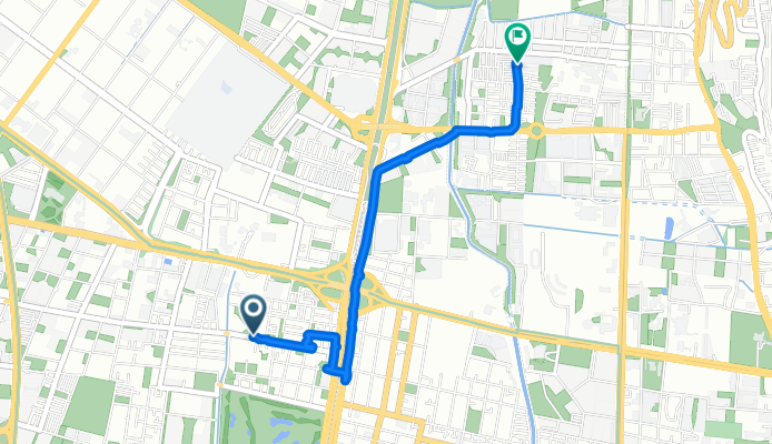
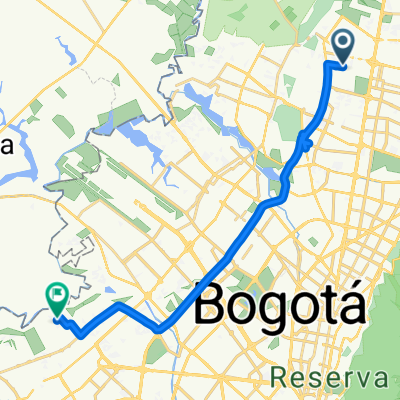
Calle 167, Bogotá a Calle 186C Bis, Bogotá
A cycling route starting in Cota, Cundinamarca, Colombia.
Overview
About this route
Start your cycling adventure at the trailhead, where the path is gently rolling with a mix of paved and unpaved surfaces. The route meanders through scenic countryside, offering stunning views at every bend. As you pedal, you'll enjoy a mix of gentle climbs and smooth descents, perfect for maintaining a steady pace.
The elevation climbs reach a maximum of 2562 meters, rewarding you with breathtaking vistas.
The descent is particularly thrilling, providing an exhilarating burst of speed before you slow down for the final stretch.
With a total distance of 4.1 kilometers and elevation changes of 22 meters ascent and 29 meters descent
AI generated
- 1 h 4 min
- Duration
- 4.1 km
- Distance
- 23 m
- Ascent
- 29 m
- Descent
- 3.9 km/h
- Avg. speed
- 2,563 m
- Max. altitude
Route quality
Waytypes & surfaces along the route
Waytypes
Cycleway
1.6 km
(38 %)
Road
1.3 km
(32 %)
Surfaces
Paved
2.6 km
(64 %)
Asphalt
2.3 km
(56 %)
Concrete
0.3 km
(8 %)
Undefined
1.5 km
(36 %)
Continue with Bikemap
Use, edit, or download this cycling route
You would like to ride Calle 167, Bogotá a Calle 186C Bis, Bogotá or customize it for your own trip? Here is what you can do with this Bikemap route:
Free features
- Save this route as favorite or in collections
- Copy & plan your own version of this route
- Sync your route with Garmin or Wahoo
Premium features
Free trial for 3 days, or one-time payment. More about Bikemap Premium.
- Navigate this route on iOS & Android
- Export a GPX / KML file of this route
- Create your custom printout (try it for free)
- Download this route for offline navigation
Discover more Premium features.
Get Bikemap PremiumFrom our community
Other popular routes starting in Cota
 De Carrera 16 6, Bogotá a Carrera 16 6, Bogotá
- Distance
- 12.8 km
- Ascent
- 45 m
- Descent
- 48 m
- Location
- Cota, Cundinamarca, Colombia
 Carrera 56, Bogotá a Carrera 97F, Bogotá
- Distance
- 23 km
- Ascent
- 104 m
- Descent
- 127 m
- Location
- Cota, Cundinamarca, Colombia
 Calle 167, Bogotá a Calle 186C Bis, Bogotá
- Distance
- 4.1 km
- Ascent
- 23 m
- Descent
- 29 m
- Location
- Cota, Cundinamarca, Colombia
 De Calle 127f # 93F-31 a Calle 127f # 93F-12
- Distance
- 64 km
- Ascent
- 607 m
- Descent
- 623 m
- Location
- Cota, Cundinamarca, Colombia
 Bogotá / Madrid / Alto el vino
- Distance
- 40.4 km
- Ascent
- 399 m
- Descent
- 106 m
- Location
- Cota, Cundinamarca, Colombia
 Calle 80 / Madrid / Alto el Vino
- Distance
- 84.9 km
- Ascent
- 469 m
- Descent
- 471 m
- Location
- Cota, Cundinamarca, Colombia
 Club de la montaña
- Distance
- 32.2 km
- Ascent
- 1,142 m
- Descent
- 1,141 m
- Location
- Cota, Cundinamarca, Colombia
 Avenida Carrera 104, Bogotá a Pinos de Lombardia, Bogotá
- Distance
- 6.9 km
- Ascent
- 25 m
- Descent
- 29 m
- Location
- Cota, Cundinamarca, Colombia
Open it in the app