
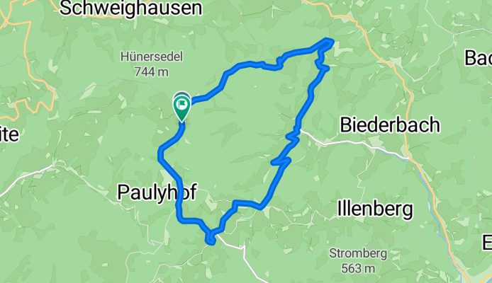
Route in Freiamt
A cycling route starting in Elzach, Baden-Wurttemberg, Germany.
Overview
About this route
- 1 h 20 min
- Duration
- 14.1 km
- Distance
- 508 m
- Ascent
- 506 m
- Descent
- 10.5 km/h
- Avg. speed
- 739 m
- Max. altitude

Route quality
Waytypes & surfaces along the route
Waytypes
Track
7.7 km
(55 %)
Quiet road
5.8 km
(41 %)
Surfaces
Paved
5.3 km
(38 %)
Unpaved
7.7 km
(55 %)
Gravel
4.8 km
(34 %)
Asphalt
3 km
(21 %)
Continue with Bikemap
Use, edit, or download this cycling route
You would like to ride Route in Freiamt or customize it for your own trip? Here is what you can do with this Bikemap route:
Free features
- Save this route as favorite or in collections
- Copy & plan your own version of this route
- Sync your route with Garmin or Wahoo
Premium features
Free trial for 3 days, or one-time payment. More about Bikemap Premium.
- Navigate this route on iOS & Android
- Export a GPX / KML file of this route
- Create your custom printout (try it for free)
- Download this route for offline navigation
Discover more Premium features.
Get Bikemap PremiumFrom our community
Other popular routes starting in Elzach
 Wanderheim Kreuzmoos
- Distance
- 7 km
- Ascent
- 189 m
- Descent
- 190 m
- Location
- Elzach, Baden-Wurttemberg, Germany
 Fuxxbande Westweg - Teil 3
- Distance
- 47.6 km
- Ascent
- 1,304 m
- Descent
- 767 m
- Location
- Elzach, Baden-Wurttemberg, Germany
 SC 53 Windener Runde über Freiamt
- Distance
- 52.9 km
- Ascent
- 1,168 m
- Descent
- 1,162 m
- Location
- Elzach, Baden-Wurttemberg, Germany
 Route in Freiamt
- Distance
- 14.1 km
- Ascent
- 508 m
- Descent
- 506 m
- Location
- Elzach, Baden-Wurttemberg, Germany
 Bust Reichenbach Runde
- Distance
- 14.8 km
- Ascent
- 445 m
- Descent
- 447 m
- Location
- Elzach, Baden-Wurttemberg, Germany
 Mont Sainte Odile (Vogesen)
- Distance
- 203.5 km
- Ascent
- 1,342 m
- Descent
- 1,338 m
- Location
- Elzach, Baden-Wurttemberg, Germany
 Siebentaeler-Rundfahrt
- Distance
- 145.7 km
- Ascent
- 2,043 m
- Descent
- 1,770 m
- Location
- Elzach, Baden-Wurttemberg, Germany
 13 ZW2 Rohrhardsbergrunde
- Distance
- 73.9 km
- Ascent
- 1,095 m
- Descent
- 1,004 m
- Location
- Elzach, Baden-Wurttemberg, Germany
Open it in the app