
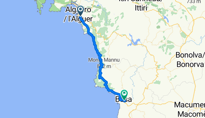
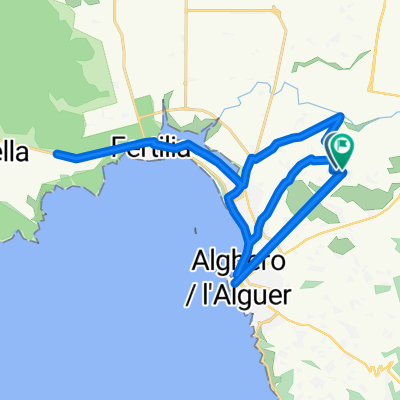
Overview
About this route
- 2 h 43 min
- Duration
- 44.2 km
- Distance
- 203 m
- Ascent
- 188 m
- Descent
- 16.3 km/h
- Avg. speed
- 218 m
- Max. altitude
Part of
Sardinien Olbia
19 stages
Continue with Bikemap
Use, edit, or download this cycling route
You would like to ride Alghero - Bosa or customize it for your own trip? Here is what you can do with this Bikemap route:
Free features
- Save this route as favorite or in collections
- Copy & plan your own version of this route
- Sync your route with Garmin or Wahoo
Premium features
Free trial for 3 days, or one-time payment. More about Bikemap Premium.
- Navigate this route on iOS & Android
- Export a GPX / KML file of this route
- Create your custom printout (try it for free)
- Download this route for offline navigation
Discover more Premium features.
Get Bikemap PremiumFrom our community
Other popular routes starting in Alghero
 Da agri a santuario valleverde
- Distance
- 24.8 km
- Ascent
- 158 m
- Descent
- 99 m
- Location
- Alghero, Sardinia, Italy
 Alghero - Stintino
- Distance
- 63.6 km
- Ascent
- 545 m
- Descent
- 556 m
- Location
- Alghero, Sardinia, Italy
 Regione la Scaletta, Alghero to Regione la Scaletta, Alghero
- Distance
- 37.9 km
- Ascent
- 806 m
- Descent
- 804 m
- Location
- Alghero, Sardinia, Italy
 Route to Porto Conte Tower
- Distance
- 15.8 km
- Ascent
- 111 m
- Descent
- 122 m
- Location
- Alghero, Sardinia, Italy
 Punta M. Fertilia
- Distance
- 66.4 km
- Ascent
- 272 m
- Descent
- 316 m
- Location
- Alghero, Sardinia, Italy
 De Strada Vicinale La Tanca de Sant'Agustì à SS128
- Distance
- 12.6 km
- Ascent
- 81 m
- Descent
- 61 m
- Location
- Alghero, Sardinia, Italy
 SS 127 bis, Alghero to Regione la Scaletta, Alghero
- Distance
- 19.1 km
- Ascent
- 268 m
- Descent
- 103 m
- Location
- Alghero, Sardinia, Italy
 De Strada Vicinale La Tanca de Sant'Agustì à Uri
- Distance
- 21.2 km
- Ascent
- 352 m
- Descent
- 276 m
- Location
- Alghero, Sardinia, Italy
Open it in the app