
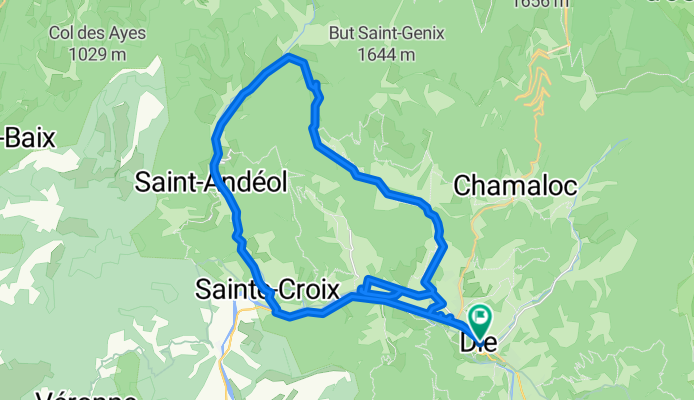
Die - Circle to St-Julien-en-Quint
A cycling route starting in Die, Auvergne-Rhône-Alpes, France.
Overview
About this route
This was a wonderful ride on excellent roads...if you eliminate the short detour we took near the start of the ride to see if we could ride just north of the Drôme River to St-Croix. However, what showed as an available road on Google Maps and as a designated bike route didn't exist beyond the point where we turned back.
The climbing was gradual and not steep. And the scenery throughout was wonderful. We highly reommend this ride.
On the ride, we passed the Col de Marignac at 743 meters.
- 23 h 46 min
- Duration
- 38.3 km
- Distance
- 556 m
- Ascent
- 553 m
- Descent
- 1.6 km/h
- Avg. speed
- 747 m
- Max. altitude

Route photos


Route quality
Waytypes & surfaces along the route
Waytypes
Road
25.6 km
(67 %)
Quiet road
1.5 km
(4 %)
Surfaces
Paved
15.7 km
(41 %)
Unpaved
0.8 km
(2 %)
Asphalt
15.7 km
(41 %)
Gravel
0.8 km
(2 %)
Undefined
21.8 km
(57 %)
Continue with Bikemap
Use, edit, or download this cycling route
You would like to ride Die - Circle to St-Julien-en-Quint or customize it for your own trip? Here is what you can do with this Bikemap route:
Free features
- Save this route as favorite or in collections
- Copy & plan your own version of this route
- Sync your route with Garmin or Wahoo
Premium features
Free trial for 3 days, or one-time payment. More about Bikemap Premium.
- Navigate this route on iOS & Android
- Export a GPX / KML file of this route
- Create your custom printout (try it for free)
- Download this route for offline navigation
Discover more Premium features.
Get Bikemap PremiumFrom our community
Other popular routes starting in Die
 2016 Ride Day 89 - Jansac to Valence
- Distance
- 90.1 km
- Ascent
- 177 m
- Descent
- 702 m
- Location
- Die, Auvergne-Rhône-Alpes, France
 Route nach Avenue de la Clairette 90, Die
- Distance
- 40.4 km
- Ascent
- 1,166 m
- Descent
- 1,165 m
- Location
- Die, Auvergne-Rhône-Alpes, France
 Die - Circle to St-Julien-en-Quint
- Distance
- 38.3 km
- Ascent
- 556 m
- Descent
- 553 m
- Location
- Die, Auvergne-Rhône-Alpes, France
 Die to Montrond
- Distance
- 66.8 km
- Ascent
- 1,363 m
- Descent
- 1,152 m
- Location
- Die, Auvergne-Rhône-Alpes, France
 Alpentocht 2015 dag 2 Definitief
- Distance
- 97 km
- Ascent
- 2,122 m
- Descent
- 1,224 m
- Location
- Die, Auvergne-Rhône-Alpes, France
 Alpentocht 2015 dag 2: Pennes-le-Sec - Grenoble
- Distance
- 105.3 km
- Ascent
- 2,211 m
- Descent
- 1,356 m
- Location
- Die, Auvergne-Rhône-Alpes, France
 Tour du Glandasse
- Distance
- 32.6 km
- Ascent
- 929 m
- Descent
- 933 m
- Location
- Die, Auvergne-Rhône-Alpes, France
 Die - La Mure + La Mure - Grenoble
- Distance
- 206.7 km
- Ascent
- 5,077 m
- Descent
- 5,302 m
- Location
- Die, Auvergne-Rhône-Alpes, France
Open it in the app