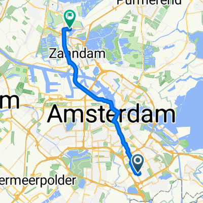
Johan Cruijff Boulevard, Amsterdã a Prins Bernhardstraat, Vianen
A cycling route starting in Amsterdam-Zuidoost, North Holland, The Netherlands.
Overview
About this route
- 3 h 11 min
 - Duration
 - 47.7 km
 - Distance
 - 90 m
 - Ascent
 - 91 m
 - Descent
 - 15 km/h
 - Avg. speed
 - 30 m
 - Max. altitude
 
Route quality
Waytypes & surfaces along the route
Waytypes
Cycleway
38.1 km
(80 %)
Quiet road
7.2 km
(15 %)
Surfaces
Paved
39.6 km
(83 %)
Asphalt
38.6 km
(81 %)
Concrete
1 km
(2 %)
Undefined
8.1 km
(17 %)
Continue with Bikemap
Use, edit, or download this cycling route
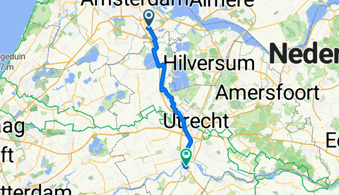
You would like to ride Johan Cruijff Boulevard, Amsterdã a Prins Bernhardstraat, Vianen or customize it for your own trip? Here is what you can do with this Bikemap route:
Free features
- Save this route as favorite or in collections
 - Copy & plan your own version of this route
 - Sync your route with Garmin or Wahoo
 
Premium features
Free trial for 3 days, or one-time payment. More about Bikemap Premium.
- Navigate this route on iOS & Android
 - Export a GPX / KML file of this route
 - Create your custom printout (try it for free)
 - Download this route for offline navigation
 
Discover more Premium features.
Get Bikemap PremiumFrom our community
Other popular routes starting in Amsterdam-Zuidoost
Hullenbergweg 385, Amsterdam nach Amstel III / Bullewijk, Amsterdam- Distance
 - 76.7 km
 - Ascent
 - 159 m
 - Descent
 - 158 m
 - Location
 - Amsterdam-Zuidoost, North Holland, The Netherlands
 
Bullewijkpad, Amsterdam nach Haarlemmerstraat 12, Amsterdam- Distance
 - 11.3 km
 - Ascent
 - 22 m
 - Descent
 - 18 m
 - Location
 - Amsterdam-Zuidoost, North Holland, The Netherlands
 
Holendrecht - Julianapark Utrecht 30 km- Distance
 - 30.2 km
 - Ascent
 - 34 m
 - Descent
 - 28 m
 - Location
 - Amsterdam-Zuidoost, North Holland, The Netherlands
 
Vecht- Distance
 - 42.3 km
 - Ascent
 - 0 m
 - Descent
 - 0 m
 - Location
 - Amsterdam-Zuidoost, North Holland, The Netherlands
 
Rondje Veen - Water - Rails - Weiland- Distance
 - 46 km
 - Ascent
 - 0 m
 - Descent
 - 0 m
 - Location
 - Amsterdam-Zuidoost, North Holland, The Netherlands
 
Reigersbos 1- Distance
 - 4.4 km
 - Ascent
 - 8 m
 - Descent
 - 8 m
 - Location
 - Amsterdam-Zuidoost, North Holland, The Netherlands
 
Waterlinie-route_370km- Distance
 - 357.5 km
 - Ascent
 - 0 m
 - Descent
 - 0 m
 - Location
 - Amsterdam-Zuidoost, North Holland, The Netherlands
 
Ede - Goch- Distance
 - 94.3 km
 - Ascent
 - 264 m
 - Descent
 - 240 m
 - Location
 - Amsterdam-Zuidoost, North Holland, The Netherlands
 
Open it in the app

