12.08.10 Familienradeln an der Alz
A cycling route starting in Obing, Bavaria, Germany.
Overview
About this route
Teststrecke noch in Bearbeitung
Aus Zeitschrift als "Familienradeln an der Alz" bezeichnet
- -:--
- Duration
- 35.9 km
- Distance
- 240 m
- Ascent
- 240 m
- Descent
- ---
- Avg. speed
- ---
- Avg. speed
Route quality
Waytypes & surfaces along the route
Waytypes
Quiet road
15.8 km
(44 %)
Track
11.8 km
(33 %)
Surfaces
Paved
20.5 km
(57 %)
Unpaved
12.6 km
(35 %)
Asphalt
19.1 km
(53 %)
Gravel
9.4 km
(26 %)
Route highlights
Points of interest along the route
Photo after 6.5 km
Kirche mit prachtvollem Flügelaltar, Friedhof mit handgeschmiedeten, alten Grabkreuzen
Photo after 11.4 km
Blick auf die Alz
Point of interest after 14.5 km
Alzfähre
Photo after 16.3 km
Sehenswerte Klosteranlage mit Kirche und Einkehrmöglichkeit.
Accommodation after 23.4 km
Einkehrmöglichkeit beim Neuwirt mit Terrasse.
Continue with Bikemap
Use, edit, or download this cycling route
You would like to ride 12.08.10 Familienradeln an der Alz or customize it for your own trip? Here is what you can do with this Bikemap route:
Free features
- Save this route as favorite or in collections
- Copy & plan your own version of this route
- Sync your route with Garmin or Wahoo
Premium features
Free trial for 3 days, or one-time payment. More about Bikemap Premium.
- Navigate this route on iOS & Android
- Export a GPX / KML file of this route
- Create your custom printout (try it for free)
- Download this route for offline navigation
Discover more Premium features.
Get Bikemap PremiumFrom our community
Other popular routes starting in Obing
- 16-Seenrunde bei Seeon
- Distance
- 69.1 km
- Ascent
- 297 m
- Descent
- 295 m
- Location
- Obing, Bavaria, Germany
- Rund um den Chiemsee 70km, 370 hm
- Distance
- 69.6 km
- Ascent
- 511 m
- Descent
- 508 m
- Location
- Obing, Bavaria, Germany
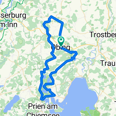
- Radtour Obing - Traunstein - Obing
- Distance
- 52.7 km
- Ascent
- 476 m
- Descent
- 476 m
- Location
- Obing, Bavaria, Germany
- 76 km Obing Trostberg Runde
- Distance
- 75.6 km
- Ascent
- 323 m
- Descent
- 322 m
- Location
- Obing, Bavaria, Germany
- Obing - Rott am Inn
- Distance
- 29.5 km
- Ascent
- 242 m
- Descent
- 330 m
- Location
- Obing, Bavaria, Germany
- Tour 3: Zur Eggstätter Seen-Platte
- Distance
- 41 km
- Ascent
- 481 m
- Descent
- 484 m
- Location
- Obing, Bavaria, Germany
- Tour 6: Staade Wege nach Kirchloibersdorf
- Distance
- 44.2 km
- Ascent
- 583 m
- Descent
- 584 m
- Location
- Obing, Bavaria, Germany
- Tour 9: Obing - Urfahrn
- Distance
- 49 km
- Ascent
- 521 m
- Descent
- 520 m
- Location
- Obing, Bavaria, Germany
Open it in the app