
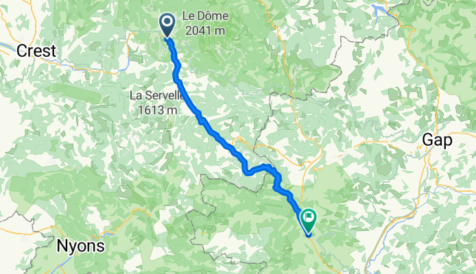
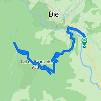
Die to Montrond
A cycling route starting in Die, Auvergne-Rhône-Alpes, France.
Overview
About this route
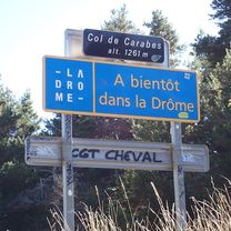
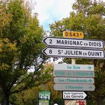
This was a challenging route with many incredible view, especially on the descent from the Col de Carabès (1261M).
The ascent to the Col was varied with one or two short but steep sections.
With the exception of the few kilometers on D1075, we saw very few vehicles. There were almost none on the climb to the Col and the descent.
This ride is highly recommended.
- 24 h 23 min
- Duration
- 66.8 km
- Distance
- 1,363 m
- Ascent
- 1,152 m
- Descent
- 2.7 km/h
- Avg. speed
- 1,267 m
- Max. altitude

Route photos


Route quality
Waytypes & surfaces along the route
Waytypes
Road
28.7 km
(43 %)
Quiet road
6 km
(9 %)
Surfaces
Paved
36.1 km
(54 %)
Asphalt
36.1 km
(54 %)
Undefined
30.7 km
(46 %)
Continue with Bikemap
Use, edit, or download this cycling route
You would like to ride Die to Montrond or customize it for your own trip? Here is what you can do with this Bikemap route:
Free features
- Save this route as favorite or in collections
- Copy & plan your own version of this route
- Sync your route with Garmin or Wahoo
Premium features
Free trial for 3 days, or one-time payment. More about Bikemap Premium.
- Navigate this route on iOS & Android
- Export a GPX / KML file of this route
- Create your custom printout (try it for free)
- Download this route for offline navigation
Discover more Premium features.
Get Bikemap PremiumFrom our community
Other popular routes starting in Die
 Die - Col du Rousset - La Chapelle-en-Vercors 85km-1600m
- Distance
- 84.3 km
- Ascent
- 1,513 m
- Descent
- 1,513 m
- Location
- Die, Auvergne-Rhône-Alpes, France
 Vercheny - Col de Penne - Die
- Distance
- 48.9 km
- Ascent
- 946 m
- Descent
- 746 m
- Location
- Die, Auvergne-Rhône-Alpes, France
 quäldich Route 2 150km
- Distance
- 73 km
- Ascent
- 2,880 m
- Descent
- 3,068 m
- Location
- Die, Auvergne-Rhône-Alpes, France
 Die to Montrond
- Distance
- 66.8 km
- Ascent
- 1,363 m
- Descent
- 1,152 m
- Location
- Die, Auvergne-Rhône-Alpes, France
 Die - Circle to St-Julien-en-Quint
- Distance
- 38.3 km
- Ascent
- 556 m
- Descent
- 553 m
- Location
- Die, Auvergne-Rhône-Alpes, France
 Alpentocht 2015 dag 2: Pennes-le-Sec - Grenoble
- Distance
- 105.3 km
- Ascent
- 2,211 m
- Descent
- 1,356 m
- Location
- Die, Auvergne-Rhône-Alpes, France
 Alpentocht 2015 dag 2 Definitief
- Distance
- 97 km
- Ascent
- 2,122 m
- Descent
- 1,224 m
- Location
- Die, Auvergne-Rhône-Alpes, France
 Die - Die über Croix de Justin
- Distance
- 17.4 km
- Ascent
- 605 m
- Descent
- 604 m
- Location
- Die, Auvergne-Rhône-Alpes, France
Open it in the app