

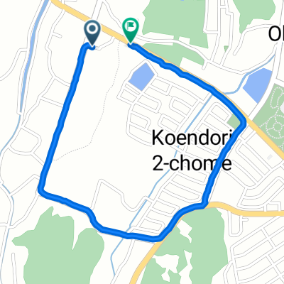
663−1 まで岡垣町
A cycling route starting in Nakama, Fukuoka, Japan.
Overview
About this route
- 30 min
- Duration
- 2.5 km
- Distance
- 92 m
- Ascent
- 116 m
- Descent
- 5.2 km/h
- Avg. speed
- 51 m
- Max. altitude
Continue with Bikemap
Use, edit, or download this cycling route
You would like to ride 663−1 まで岡垣町 or customize it for your own trip? Here is what you can do with this Bikemap route:
Free features
- Save this route as favorite or in collections
- Copy & plan your own version of this route
- Sync your route with Garmin or Wahoo
Premium features
Free trial for 3 days, or one-time payment. More about Bikemap Premium.
- Navigate this route on iOS & Android
- Export a GPX / KML file of this route
- Create your custom printout (try it for free)
- Download this route for offline navigation
Discover more Premium features.
Get Bikemap PremiumFrom our community
Other popular routes starting in Nakama
 菅原町6-31, 北九州市八幡西区 to 篠栗985, 糟屋郡篠栗町
- Distance
- 55 km
- Ascent
- 475 m
- Descent
- 376 m
- Location
- Nakama, Fukuoka, Japan
 2-chōme 4, Okagaki to 3-chōme 10, Fukuoka
- Distance
- 56 km
- Ascent
- 266 m
- Descent
- 305 m
- Location
- Nakama, Fukuoka, Japan
 1-33, Sugawaramachi, Yahatanishi-Ku, Kitakyushu to 1339, Imatobaru, Oto, Tagawa-Gun
- Distance
- 32.9 km
- Ascent
- 3 m
- Descent
- 9 m
- Location
- Nakama, Fukuoka, Japan
 Tobata to Mizumaki route
- Distance
- 11.6 km
- Ascent
- 0 m
- Descent
- 0 m
- Location
- Nakama, Fukuoka, Japan
 283-8, Yamaga, Ashiya, Onga-Gun naar 1-2, Arukapoto, Shimonoseki
- Distance
- 40.3 km
- Ascent
- 459 m
- Descent
- 470 m
- Location
- Nakama, Fukuoka, Japan
 654−1 まで岡垣町
- Distance
- 2.6 km
- Ascent
- 46 m
- Descent
- 81 m
- Location
- Nakama, Fukuoka, Japan
 663−1 まで岡垣町
- Distance
- 2.5 km
- Ascent
- 92 m
- Descent
- 116 m
- Location
- Nakama, Fukuoka, Japan
 653−1 まで岡垣町
- Distance
- 2.9 km
- Ascent
- 82 m
- Descent
- 133 m
- Location
- Nakama, Fukuoka, Japan
Open it in the app