

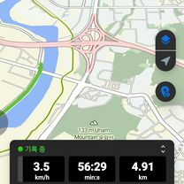
느린 주행
A cycling route starting in Gwangju, Gwangju, South Korea.
Overview
About this route
- 53 min
- Duration
- 10 km
- Distance
- 68 m
- Ascent
- 80 m
- Descent
- 11.3 km/h
- Avg. speed
- 53 m
- Max. altitude

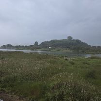
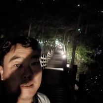
Route photos

Continue with Bikemap
Use, edit, or download this cycling route
You would like to ride 느린 주행 or customize it for your own trip? Here is what you can do with this Bikemap route:
Free features
- Save this route as favorite or in collections
- Copy & plan your own version of this route
- Sync your route with Garmin or Wahoo
Premium features
Free trial for 3 days, or one-time payment. More about Bikemap Premium.
- Navigate this route on iOS & Android
- Export a GPX / KML file of this route
- Create your custom printout (try it for free)
- Download this route for offline navigation
Discover more Premium features.
Get Bikemap PremiumFrom our community
Other popular routes starting in Gwangju
![Ph0]에서 경로담양읍 125-1](https://media.bikemap.net/routes/17660114/gallery/thumbs/f8457a01-53cd-4d33-90a0-a60c5324934f.jpg.208x208_q80_crop.jpg) Ph0]에서 경로담양읍 125-1
Ph0]에서 경로담양읍 125-1- Distance
- 20.3 km
- Ascent
- 61 m
- Descent
- 111 m
- Location
- Gwangju, Gwangju, South Korea
![Ph0]에서 경로봉산면 1197-7](https://media.bikemap.net/routes/17656637/gallery/thumbs/90afd928-d34c-4ea6-a2b3-bb9aed911fc3.jpg.208x208_q80_crop.jpg) Ph0]에서 경로봉산면 1197-7
Ph0]에서 경로봉산면 1197-7- Distance
- 5.7 km
- Ascent
- 18 m
- Descent
- 29 m
- Location
- Gwangju, Gwangju, South Korea
 남면 863-1 ~ 남면 874-3
- Distance
- 3.8 km
- Ascent
- 18 m
- Descent
- 51 m
- Location
- Gwangju, Gwangju, South Korea
 느린 주행
느린 주행- Distance
- 10 km
- Ascent
- 68 m
- Descent
- 80 m
- Location
- Gwangju, Gwangju, South Korea
 편안한 경로
- Distance
- 5.2 km
- Ascent
- 13 m
- Descent
- 24 m
- Location
- Gwangju, Gwangju, South Korea
 계림동 ~ 계림동 523-15
- Distance
- 10.4 km
- Ascent
- 136 m
- Descent
- 177 m
- Location
- Gwangju, Gwangju, South Korea
 신창동 1108-2 ~ 대한민국
- Distance
- 90.4 km
- Ascent
- 651 m
- Descent
- 697 m
- Location
- Gwangju, Gwangju, South Korea
 신가동 992-1 ~ 대한민국
- Distance
- 1.4 km
- Ascent
- 89 m
- Descent
- 114 m
- Location
- Gwangju, Gwangju, South Korea
Open it in the app