
Radweg bis Oberthern und über Puch heim
A cycling route starting in Stetteldorf am Wagram, Lower Austria, Austria.
Overview
About this route
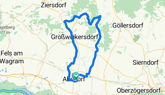
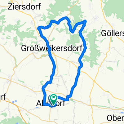
Embark on a scenic 42.3 km cycling adventure through diverse landscapes. Begin at the start point and enjoy 343 meters of ascent with a maximum elevation of 366 meters. The route features a mix of surfaces, including 19,053 meters of smooth asphalt and 18,180 meters of varied terrain, with 52.2% of the journey on the regional bike network.
- 1 h 40 min
- Duration
- 42.3 km
- Distance
- 343 m
- Ascent
- 340 m
- Descent
- 25.3 km/h
- Avg. speed
- 367 m
- Max. altitude

Route quality
Waytypes & surfaces along the route
Waytypes
Quiet road
15.2 km
(36 %)
Road
14 km
(33 %)
Surfaces
Paved
23.3 km
(55 %)
Unpaved
0.8 km
(2 %)
Asphalt
19 km
(45 %)
Paved (undefined)
3.4 km
(8 %)
Continue with Bikemap
Use, edit, or download this cycling route
You would like to ride Radweg bis Oberthern und über Puch heim or customize it for your own trip? Here is what you can do with this Bikemap route:
Free features
- Save this route as favorite or in collections
- Copy & plan your own version of this route
- Sync your route with Garmin or Wahoo
Premium features
Free trial for 3 days, or one-time payment. More about Bikemap Premium.
- Navigate this route on iOS & Android
- Export a GPX / KML file of this route
- Create your custom printout (try it for free)
- Download this route for offline navigation
Discover more Premium features.
Get Bikemap PremiumFrom our community
Other popular routes starting in Stetteldorf am Wagram
 Radweg bis Oberthern und über Puch heim
- Distance
- 42.3 km
- Ascent
- 343 m
- Descent
- 340 m
- Location
- Stetteldorf am Wagram, Lower Austria, Austria
 Absdorf_Wien
- Distance
- 51.7 km
- Ascent
- 108 m
- Descent
- 104 m
- Location
- Stetteldorf am Wagram, Lower Austria, Austria
 Nach Ziersdorf 40km
- Distance
- 40.7 km
- Ascent
- 200 m
- Descent
- 201 m
- Location
- Stetteldorf am Wagram, Lower Austria, Austria
 Tulln - Melk - Tulln
- Distance
- 147 km
- Ascent
- 446 m
- Descent
- 448 m
- Location
- Stetteldorf am Wagram, Lower Austria, Austria
 Neubaugasse, Absdorf nach Neubaugasse, Absdorf
- Distance
- 46.2 km
- Ascent
- 46 m
- Descent
- 50 m
- Location
- Stetteldorf am Wagram, Lower Austria, Austria
 Bierbaum-Feuersbrunn-B
- Distance
- 38.5 km
- Ascent
- 121 m
- Descent
- 120 m
- Location
- Stetteldorf am Wagram, Lower Austria, Austria
 Tulln-Runde
- Distance
- 45.9 km
- Ascent
- 20 m
- Descent
- 22 m
- Location
- Stetteldorf am Wagram, Lower Austria, Austria
 Neuaigen-Altenwörth-Donau-Runde
- Distance
- 52.9 km
- Ascent
- 98 m
- Descent
- 100 m
- Location
- Stetteldorf am Wagram, Lower Austria, Austria
Open it in the app