

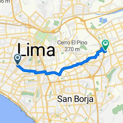
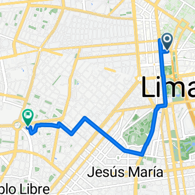
Jirón Jacinto Lopez, Lima a Plaza de la Bandera, Lima
A cycling route starting in Lima, Lima Province, Peru.
Overview
About this route
Embark on an exhilarating 5.5 km cycling adventure from Oyetec in Lima to the vibrant Plaza de la Bandera. This route offers a perfect blend of smooth paved paths and scenic bike lanes, ideal for both casual rides and spirited explorations.
As you pedal, you'll cruise on well-maintained asfalto roads for a substantial portion of the journey, covering 4984 meters (approximately 90.2%) of the route. The path is predominantly flat, with just a gentle ascent of 3 meters and a descent of 49 meters, keeping the ride enjoyable and accessible for all.
You'll glide over 2248 meters on dedicated bike lanes (40.7%), enjoying a safe and scenic ride alongside the city. The journey culminates at the iconic Plaza de la Bandera, where you can soak in the lively atmosphere and admire the historic surroundings.
This route is perfect for those looking to explore Lima's dynamic urban landscape while staying active and engaged. Whether you're commuting or just enjoying a leisurely ride, this cycling path promises a pleasant and rewarding experience.
AI generated
- 21 min
- Duration
- 5.5 km
- Distance
- 4 m
- Ascent
- 50 m
- Descent
- 15.5 km/h
- Avg. speed
- 149 m
- Max. altitude
Route quality
Waytypes & surfaces along the route
Waytypes
Quiet road
2.6 km
(47 %)
Cycleway
2.2 km
(40 %)
Surfaces
Paved
4.9 km
(88 %)
Unpaved
0.1 km
(1 %)
Asphalt
3.9 km
(71 %)
Concrete
0.7 km
(13 %)
Continue with Bikemap
Use, edit, or download this cycling route
You would like to ride Jirón Jacinto Lopez, Lima a Plaza de la Bandera, Lima or customize it for your own trip? Here is what you can do with this Bikemap route:
Free features
- Save this route as favorite or in collections
- Copy & plan your own version of this route
- Sync your route with Garmin or Wahoo
Premium features
Free trial for 3 days, or one-time payment. More about Bikemap Premium.
- Navigate this route on iOS & Android
- Export a GPX / KML file of this route
- Create your custom printout (try it for free)
- Download this route for offline navigation
Discover more Premium features.
Get Bikemap PremiumFrom our community
Other popular routes starting in Lima
 Azangaro Street, Lima to Jirón Carlos Arrieta, Lima
- Distance
- 6.2 km
- Ascent
- 47 m
- Descent
- 80 m
- Location
- Lima, Lima Province, Peru
 Avenida Del Rio, Lima a Departamento de Lima
- Distance
- 12.2 km
- Ascent
- 135 m
- Descent
- 0 m
- Location
- Lima, Lima Province, Peru
 ir al trabajo
- Distance
- 15.9 km
- Ascent
- 53 m
- Descent
- 87 m
- Location
- Lima, Lima Province, Peru
 San Juan de Lurigancho a ISIL Miraflores
- Distance
- 17.6 km
- Ascent
- 60 m
- Descent
- 180 m
- Location
- Lima, Lima Province, Peru
 De Jirón Ucayali a Jirón Ucayali
- Distance
- 10.4 km
- Ascent
- 87 m
- Descent
- 113 m
- Location
- Lima, Lima Province, Peru
 Ruta Dominguera
- Distance
- 17.9 km
- Ascent
- 335 m
- Descent
- 331 m
- Location
- Lima, Lima Province, Peru
 Jirón Jacinto Lopez, Lima a Plaza de la Bandera, Lima
- Distance
- 5.5 km
- Ascent
- 4 m
- Descent
- 50 m
- Location
- Lima, Lima Province, Peru
 Avenida Óscar Raimundo Benavides, Lima a Avenida Carlos Germán Amezaga, Lima
- Distance
- 3.6 km
- Ascent
- 3 m
- Descent
- 51 m
- Location
- Lima, Lima Province, Peru
Open it in the app