
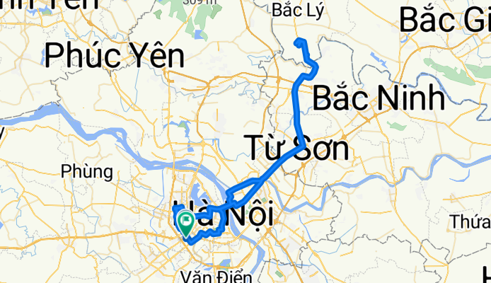
Lê Văn Thiêm, Hà Nội to Lê Văn Thiêm, Hà Nội
A cycling route starting in Thanh Xuân, Hanoi, Vietnam.
Overview
About this route
- 5 h 36 min
- Duration
- 98.9 km
- Distance
- 681 m
- Ascent
- 681 m
- Descent
- 17.6 km/h
- Avg. speed
- 24 m
- Max. altitude

Route photos


Route quality
Waytypes & surfaces along the route
Waytypes
Quiet road
18.8 km
(19 %)
Road
6.9 km
(7 %)
Surfaces
Paved
52.4 km
(53 %)
Asphalt
51.4 km
(52 %)
Concrete
1 km
(1 %)
Undefined
46.5 km
(47 %)
Continue with Bikemap
Use, edit, or download this cycling route
You would like to ride Lê Văn Thiêm, Hà Nội to Lê Văn Thiêm, Hà Nội or customize it for your own trip? Here is what you can do with this Bikemap route:
Free features
- Save this route as favorite or in collections
- Copy & plan your own version of this route
- Split it into stages to create a multi-day tour
- Sync your route with Garmin or Wahoo
Premium features
Free trial for 3 days, or one-time payment. More about Bikemap Premium.
- Navigate this route on iOS & Android
- Export a GPX / KML file of this route
- Create your custom printout (try it for free)
- Download this route for offline navigation
Discover more Premium features.
Get Bikemap PremiumFrom our community
Other popular routes starting in Thanh Xuân
 Ngụy Như Kon Tum, Hà Nội to Lê Văn Lương, Hà Nội
- Distance
- 74.7 km
- Ascent
- 879 m
- Descent
- 875 m
- Location
- Thanh Xuân, Hanoi, Vietnam
 P. Thanh Xuân Trung, Hà Nội to Ngụy Như Kon Tum, Hà Nội
- Distance
- 32.6 km
- Ascent
- 97 m
- Descent
- 96 m
- Location
- Thanh Xuân, Hanoi, Vietnam
 Ngụy Như Kon Tum, Hà Nội to Ngụy Như Kon Tum, Hà Nội
- Distance
- 83.5 km
- Ascent
- 337 m
- Descent
- 340 m
- Location
- Thanh Xuân, Hanoi, Vietnam
 Ngụy Như Kon Tum, Hà Nội to Lê Văn Thiêm, Hà Nội
- Distance
- 83.8 km
- Ascent
- 301 m
- Descent
- 303 m
- Location
- Thanh Xuân, Hanoi, Vietnam
 P. Thanh Xuân Trung, Hà Nội to Ngụy Như Kon Tum, Hà Nội
- Distance
- 47.8 km
- Ascent
- 98 m
- Descent
- 97 m
- Location
- Thanh Xuân, Hanoi, Vietnam
 P. Thanh Xuân Trung, Hà Nội to P. Thanh Xuân Trung, Hà Nội
- Distance
- 77.7 km
- Ascent
- 783 m
- Descent
- 786 m
- Location
- Thanh Xuân, Hanoi, Vietnam
 Lê Văn Thiêm, Hà Nội to Ngụy Như Kon Tum, Hà Nội
- Distance
- 41.8 km
- Ascent
- 136 m
- Descent
- 133 m
- Location
- Thanh Xuân, Hanoi, Vietnam
 Lê Văn Thiêm, Hà Nội to Lê Văn Thiêm, Hà Nội
- Distance
- 98.9 km
- Ascent
- 681 m
- Descent
- 681 m
- Location
- Thanh Xuân, Hanoi, Vietnam
Open it in the app