
PASSO PINEI/ PAINDERSATTEL (por Castelrotto)
A cycling route starting in Kastelruth, Trentino-Alto Adige, Italy.
Overview
About this route
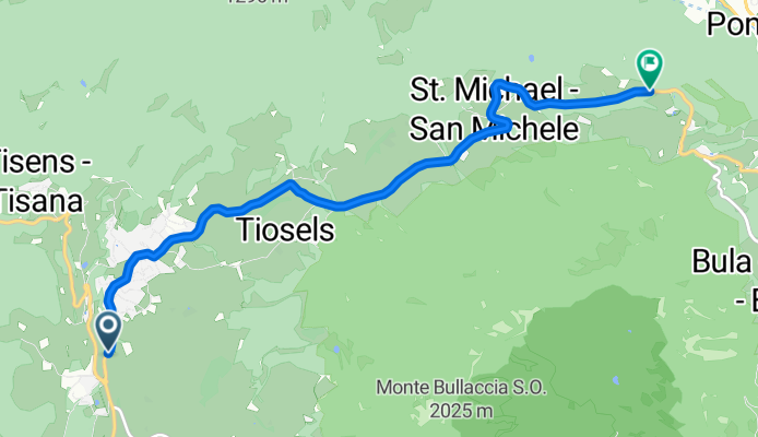
Passo Pinei (1,444 m), known in German as Panidersattel, is a mountain pass that connects the Val Gardena (Gröden) and the Eisack Valley (Val d'Isarco), in the heart of South Tyrol. From Castelrotto (Kastelruth), the western flank offers a short but very steady climb, typical of the lower Dolomites, where the elevation gain is concentrated in a few kilometres.
- 38 min
- Duration
- 7.4 km
- Distance
- 423 m
- Ascent
- 68 m
- Descent
- 11.5 km/h
- Avg. speed
- 1,450 m
- Max. altitude

Route photos
\"")
Route quality
Waytypes & surfaces along the route
Surfaces
Paved
2.8 km
(38 %)
Asphalt
2.8 km
(38 %)
Undefined
4.6 km
(62 %)
Continue with Bikemap
Use, edit, or download this cycling route
You would like to ride PASSO PINEI/ PAINDERSATTEL (por Castelrotto) or customize it for your own trip? Here is what you can do with this Bikemap route:
Free features
- Save this route as favorite or in collections
- Copy & plan your own version of this route
- Sync your route with Garmin or Wahoo
Premium features
Free trial for 3 days, or one-time payment. More about Bikemap Premium.
- Navigate this route on iOS & Android
- Export a GPX / KML file of this route
- Create your custom printout (try it for free)
- Download this route for offline navigation
Discover more Premium features.
Get Bikemap PremiumFrom our community
Other popular routes starting in Kastelruth
 Kastelruth-Panorama
- Distance
- 40.5 km
- Ascent
- 1,233 m
- Descent
- 1,233 m
- Location
- Kastelruth, Trentino-Alto Adige, Italy
 11.7. - Kastelruth - Weisslahnbad
- Distance
- 51.1 km
- Ascent
- 1,088 m
- Descent
- 1,089 m
- Location
- Kastelruth, Trentino-Alto Adige, Italy
 Ortisei Scigliar Castelrotto da fare al contrario
- Distance
- 51.3 km
- Ascent
- 1,434 m
- Descent
- 1,440 m
- Location
- Kastelruth, Trentino-Alto Adige, Italy
 seiser alm
- Distance
- 22.2 km
- Ascent
- 774 m
- Descent
- 778 m
- Location
- Kastelruth, Trentino-Alto Adige, Italy
 Tierscher Alpl
- Distance
- 43.9 km
- Ascent
- 1,596 m
- Descent
- 1,597 m
- Location
- Kastelruth, Trentino-Alto Adige, Italy
 Castelrotto-Cortina
- Distance
- 41 km
- Ascent
- 1,801 m
- Descent
- 1,255 m
- Location
- Kastelruth, Trentino-Alto Adige, Italy
 Telfen 58, Telfen-Lanzin do Telfen-Lanzin 59a, Castelrotto
- Distance
- 14 km
- Ascent
- 1 m
- Descent
- 77 m
- Location
- Kastelruth, Trentino-Alto Adige, Italy
 St.Oswald-Kastelruth-Seiser Alm-Seis-St.Oswald
- Distance
- 35.9 km
- Ascent
- 1,313 m
- Descent
- 1,281 m
- Location
- Kastelruth, Trentino-Alto Adige, Italy
Open it in the app