동동 222-1 ~ 언양읍 1044-1
A cycling route starting in Ulsan, Ulsan, South Korea.
Overview
About this route
- 1 h 59 min
- Duration
- 31.1 km
- Distance
- 126 m
- Ascent
- 137 m
- Descent
- 15.7 km/h
- Avg. speed
- 67 m
- Max. altitude
Route photos
Continue with Bikemap
Use, edit, or download this cycling route
You would like to ride 동동 222-1 ~ 언양읍 1044-1 or customize it for your own trip? Here is what you can do with this Bikemap route:
Free features
- Save this route as favorite or in collections
- Copy & plan your own version of this route
- Sync your route with Garmin or Wahoo
Premium features
Free trial for 3 days, or one-time payment. More about Bikemap Premium.
- Navigate this route on iOS & Android
- Export a GPX / KML file of this route
- Create your custom printout (try it for free)
- Download this route for offline navigation
Discover more Premium features.
Get Bikemap PremiumFrom our community
Other popular routes starting in Ulsan
- Ph0]에서 경로달동 1355-10
- Distance
- 9.1 km
- Ascent
- 80 m
- Descent
- 107 m
- Location
- Ulsan, Ulsan, South Korea
- 동동 222-1 ~ 언양읍 1044-1
- Distance
- 31.1 km
- Ascent
- 126 m
- Descent
- 137 m
- Location
- Ulsan, Ulsan, South Korea
- Seongnam-dong 199-1 to Oedong-eup 398-2, Gyeongju
- Distance
- 18.9 km
- Ascent
- 222 m
- Descent
- 179 m
- Location
- Ulsan, Ulsan, South Korea
- Taehwa-dong 77-1 to Nammok 2(i)-dong 924
- Distance
- 14.8 km
- Ascent
- 262 m
- Descent
- 261 m
- Location
- Ulsan, Ulsan, South Korea
- Taehwa-dong 596-5 to Oedong-eup 398-2, Gyeongju
- Distance
- 19.1 km
- Ascent
- 346 m
- Descent
- 301 m
- Location
- Ulsan, Ulsan, South Korea
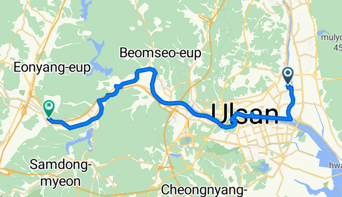
- 신정동, 울산광역시에서 신정동, 울산광역시까지
- Distance
- 50.2 km
- Ascent
- 303 m
- Descent
- 321 m
- Location
- Ulsan, Ulsan, South Korea
- 온양읍 183 to 서생면 84−11
- Distance
- 12.6 km
- Ascent
- 25 m
- Descent
- 34 m
- Location
- Ulsan, Ulsan, South Korea
- 상안동, 울산광역시에서 호계로, 울산광역시까지
- Distance
- 45.4 km
- Ascent
- 384 m
- Descent
- 383 m
- Location
- Ulsan, Ulsan, South Korea
Open it in the app