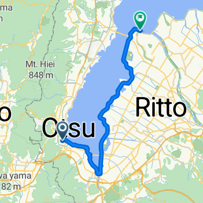
Ōtsu - Nara
A cycling route starting in Ōtsu, Shiga Prefecture, Japan.
Overview
About this route
- 3 h 1 min
- Duration
- 54.5 km
- Distance
- 318 m
- Ascent
- 367 m
- Descent
- 18 km/h
- Avg. speed
- 222 m
- Max. altitude
Route quality
Waytypes & surfaces along the route
Waytypes
Cycleway
33.8 km
(62 %)
Road
9.8 km
(18 %)
Surfaces
Paved
16.3 km
(30 %)
Asphalt
8.7 km
(16 %)
Paved (undefined)
7.1 km
(13 %)
Continue with Bikemap
Use, edit, or download this cycling route
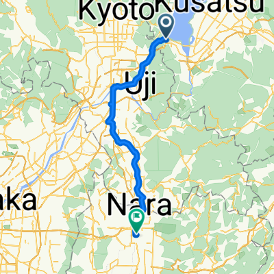
You would like to ride Ōtsu - Nara or customize it for your own trip? Here is what you can do with this Bikemap route:
Free features
- Save this route as favorite or in collections
- Copy & plan your own version of this route
- Sync your route with Garmin or Wahoo
Premium features
Free trial for 3 days, or one-time payment. More about Bikemap Premium.
- Navigate this route on iOS & Android
- Export a GPX / KML file of this route
- Create your custom printout (try it for free)
- Download this route for offline navigation
Discover more Premium features.
Get Bikemap PremiumFrom our community
Other popular routes starting in Ōtsu
Ōtsu - Nara- Distance
- 54.5 km
- Ascent
- 318 m
- Descent
- 367 m
- Location
- Ōtsu, Shiga Prefecture, Japan
Steady ride- Distance
- 45.3 km
- Ascent
- 561 m
- Descent
- 649 m
- Location
- Ōtsu, Shiga Prefecture, Japan
琵琶湖环游- Distance
- 206.3 km
- Ascent
- 853 m
- Descent
- 882 m
- Location
- Ōtsu, Shiga Prefecture, Japan
otsu to niju, kyoto- Distance
- 14.9 km
- Ascent
- 194 m
- Descent
- 271 m
- Location
- Ōtsu, Shiga Prefecture, Japan
Otsu-Omihachiman- Distance
- 46.6 km
- Ascent
- 256 m
- Descent
- 249 m
- Location
- Ōtsu, Shiga Prefecture, Japan
5, Otsu to Nagahama- Distance
- 88.5 km
- Ascent
- 406 m
- Descent
- 406 m
- Location
- Ōtsu, Shiga Prefecture, Japan
浜大津5丁目, 大津市へ浜大津5丁目, 大津市- Distance
- 44 km
- Ascent
- 142 m
- Descent
- 140 m
- Location
- Ōtsu, Shiga Prefecture, Japan
2016Tour-Otsu- Distance
- 12.2 km
- Ascent
- 232 m
- Descent
- 303 m
- Location
- Ōtsu, Shiga Prefecture, Japan
Open it in the app


