
Portugal
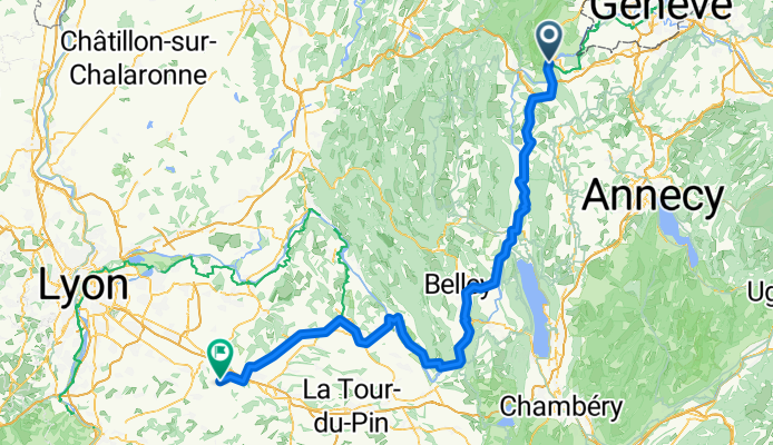
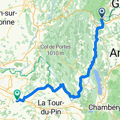
Collonges - Villefontaine
A cycling route starting in Collonges, Auvergne-Rhône-Alpes, France.
Overview
About this route
- 7 h 52 min
- Duration
- 138.9 km
- Distance
- 997 m
- Ascent
- 1,137 m
- Descent
- 17.7 km/h
- Avg. speed
- 574 m
- Max. altitude

Part of
Portugal
7 stages
Route quality
Waytypes & surfaces along the route
Waytypes
Cycleway
48.6 km
(35 %)
Quiet road
33.3 km
(24 %)
Surfaces
Paved
84.7 km
(61 %)
Unpaved
6.9 km
(5 %)
Asphalt
81.9 km
(59 %)
Loose gravel
6.9 km
(5 %)
Continue with Bikemap
Use, edit, or download this cycling route
You would like to ride Collonges - Villefontaine or customize it for your own trip? Here is what you can do with this Bikemap route:
Free features
- Save this route as favorite or in collections
- Copy & plan your own version of this route
- Split it into stages to create a multi-day tour
- Sync your route with Garmin or Wahoo
Premium features
Free trial for 3 days, or one-time payment. More about Bikemap Premium.
- Navigate this route on iOS & Android
- Export a GPX / KML file of this route
- Create your custom printout (try it for free)
- Download this route for offline navigation
Discover more Premium features.
Get Bikemap PremiumFrom our community
Other popular routes starting in Collonges
 von Genf nach Lyon - Tag 2 - von Collonges nach Seyssel
- Distance
- 32 km
- Ascent
- 535 m
- Descent
- 778 m
- Location
- Collonges, Auvergne-Rhône-Alpes, France
 Collonges - Burtigny (Jura)
- Distance
- 110.1 km
- Ascent
- 2,213 m
- Descent
- 1,608 m
- Location
- Collonges, Auvergne-Rhône-Alpes, France
 Tour du Vuache
- Distance
- 25.2 km
- Ascent
- 452 m
- Descent
- 457 m
- Location
- Collonges, Auvergne-Rhône-Alpes, France
 Route de Vulbens 9, Chevrier nach Route de Genève 15, Seyssel
- Distance
- 23.8 km
- Ascent
- 270 m
- Descent
- 440 m
- Location
- Collonges, Auvergne-Rhône-Alpes, France
 Rue du Fort 218, Collonges nach Route du Bois-des-Frères 40, Le Lignon
- Distance
- 27.5 km
- Ascent
- 229 m
- Descent
- 311 m
- Location
- Collonges, Auvergne-Rhône-Alpes, France
 Rue du Fort 218, Collonges nach Rue de la Mairie 22, Culoz
- Distance
- 48.6 km
- Ascent
- 612 m
- Descent
- 860 m
- Location
- Collonges, Auvergne-Rhône-Alpes, France
 Collonges - Villefontaine
- Distance
- 138.9 km
- Ascent
- 997 m
- Descent
- 1,137 m
- Location
- Collonges, Auvergne-Rhône-Alpes, France
 st ju poezat
- Distance
- 284.5 km
- Ascent
- 2,951 m
- Descent
- 3,014 m
- Location
- Collonges, Auvergne-Rhône-Alpes, France
Open it in the app