

De Calle Moreras a Calle José Luis Iniesta Vázquez
A cycling route starting in Badajoz, Extremadura, Spain.
Overview
About this route
- 3 h 33 min
- Duration
- 19.8 km
- Distance
- 291 m
- Ascent
- 355 m
- Descent
- 5.6 km/h
- Avg. speed
- 244 m
- Max. altitude

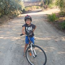
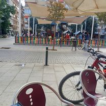
Route photos


Route quality
Waytypes & surfaces along the route
Waytypes
Quiet road
6.7 km
(34 %)
Track
6.1 km
(31 %)
Surfaces
Paved
4.9 km
(25 %)
Asphalt
4.9 km
(25 %)
Undefined
14.8 km
(75 %)
Continue with Bikemap
Use, edit, or download this cycling route
You would like to ride De Calle Moreras a Calle José Luis Iniesta Vázquez or customize it for your own trip? Here is what you can do with this Bikemap route:
Free features
- Save this route as favorite or in collections
- Copy & plan your own version of this route
- Sync your route with Garmin or Wahoo
Premium features
Free trial for 3 days, or one-time payment. More about Bikemap Premium.
- Navigate this route on iOS & Android
- Export a GPX / KML file of this route
- Create your custom printout (try it for free)
- Download this route for offline navigation
Discover more Premium features.
Get Bikemap PremiumFrom our community
Other popular routes starting in Badajoz
 De Calle Somoza Rivera 22, Badajoz a Calle Somoza Rivera 22, Badajoz
- Distance
- 19.2 km
- Ascent
- 106 m
- Descent
- 108 m
- Location
- Badajoz, Extremadura, Spain
 Badajoz - Las Vaguadas - Los Montitos - San Isidro - 3 arroyos - Cerro Gordo - Badajoz
- Distance
- 39.6 km
- Ascent
- 268 m
- Descent
- 268 m
- Location
- Badajoz, Extremadura, Spain
 De ¿Ô¡Ê? a ¿Ô¡Ê?
- Distance
- 18.5 km
- Ascent
- 56 m
- Descent
- 58 m
- Location
- Badajoz, Extremadura, Spain
 Badajoz - El Manantío - Los Montitos - Badajoz
- Distance
- 43.1 km
- Ascent
- 234 m
- Descent
- 233 m
- Location
- Badajoz, Extremadura, Spain
 ruta
ruta- Distance
- 13.6 km
- Ascent
- 138 m
- Descent
- 140 m
- Location
- Badajoz, Extremadura, Spain
 Day 8 | Badajoz to Elvas
- Distance
- 22.6 km
- Ascent
- 94 m
- Descent
- 48 m
- Location
- Badajoz, Extremadura, Spain
 De Calle Moreras a Calle José Luis Iniesta Vázquez
- Distance
- 19.8 km
- Ascent
- 291 m
- Descent
- 355 m
- Location
- Badajoz, Extremadura, Spain
 Ruta puente dé hierro
- Distance
- 31.3 km
- Ascent
- 557 m
- Descent
- 645 m
- Location
- Badajoz, Extremadura, Spain
Open it in the app