
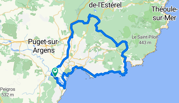
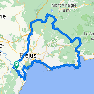
Fréjus MTB
A cycling route starting in Fréjus, Provence-Alpes-Côte d'Azur Region, France.
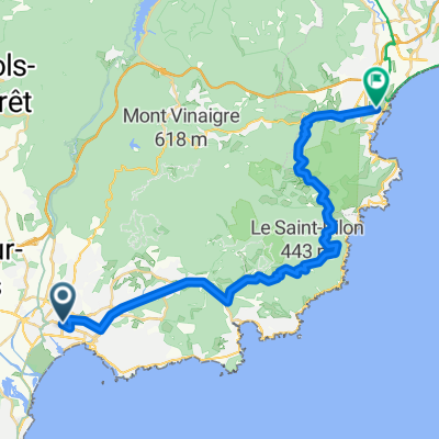
Overview
About this route
- 10 h 56 min
- Duration
- 58.9 km
- Distance
- 1,115 m
- Ascent
- 1,117 m
- Descent
- 5.4 km/h
- Avg. speed
- 400 m
- Max. altitude
Route quality
Waytypes & surfaces along the route
Waytypes
Path
21.2 km
(36 %)
Quiet road
11.2 km
(19 %)
Surfaces
Paved
23 km
(39 %)
Unpaved
17.7 km
(30 %)
Asphalt
22.4 km
(38 %)
Gravel
9.4 km
(16 %)
Continue with Bikemap
Use, edit, or download this cycling route
You would like to ride Fréjus MTB or customize it for your own trip? Here is what you can do with this Bikemap route:
Free features
- Save this route as favorite or in collections
- Copy & plan your own version of this route
- Sync your route with Garmin or Wahoo
Premium features
Free trial for 3 days, or one-time payment. More about Bikemap Premium.
- Navigate this route on iOS & Android
- Export a GPX / KML file of this route
- Create your custom printout (try it for free)
- Download this route for offline navigation
Discover more Premium features.
Get Bikemap PremiumFrom our community
Other popular routes starting in Fréjus
 saint-aygulf - Bagnoles en foret
- Distance
- 27.1 km
- Ascent
- 432 m
- Descent
- 115 m
- Location
- Fréjus, Provence-Alpes-Côte d'Azur Region, France
 S Frankreich 1. Tag
- Distance
- 58.1 km
- Ascent
- 511 m
- Descent
- 511 m
- Location
- Fréjus, Provence-Alpes-Côte d'Azur Region, France
 Fréjus MTB
- Distance
- 58.9 km
- Ascent
- 1,115 m
- Descent
- 1,117 m
- Location
- Fréjus, Provence-Alpes-Côte d'Azur Region, France
 2^ TAPPA Frejus-Bormes les Mimosas
- Distance
- 60.8 km
- Ascent
- 320 m
- Descent
- 282 m
- Location
- Fréjus, Provence-Alpes-Côte d'Azur Region, France
 Frejus 71km 1380hm
- Distance
- 71.6 km
- Ascent
- 1,386 m
- Descent
- 1,384 m
- Location
- Fréjus, Provence-Alpes-Côte d'Azur Region, France
 Frejus to MPL
- Distance
- 33.4 km
- Ascent
- 1,334 m
- Descent
- 1,333 m
- Location
- Fréjus, Provence-Alpes-Côte d'Azur Region, France
 St. Aygulf - Le Muy - Bagnols en Fôret - Frejus - St.Aygulf
- Distance
- 62.9 km
- Ascent
- 588 m
- Descent
- 595 m
- Location
- Fréjus, Provence-Alpes-Côte d'Azur Region, France
 Nördlich von Fréjus
- Distance
- 48.3 km
- Ascent
- 905 m
- Descent
- 905 m
- Location
- Fréjus, Provence-Alpes-Côte d'Azur Region, France
Open it in the app