

Poiana Rotundă
A cycling route starting in Floreşti, Cluj County, Romania.
Overview
About this route
- 4 h 36 min
- Duration
- 32.3 km
- Distance
- 558 m
- Ascent
- 585 m
- Descent
- 7 km/h
- Avg. speed
- 622 m
- Max. altitude

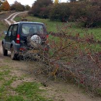
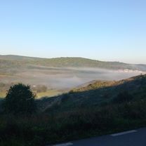
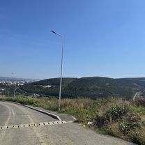
Route photos


Continue with Bikemap
Use, edit, or download this cycling route
You would like to ride Poiana Rotundă or customize it for your own trip? Here is what you can do with this Bikemap route:
Free features
- Save this route as favorite or in collections
- Copy & plan your own version of this route
- Sync your route with Garmin or Wahoo
Premium features
Free trial for 3 days, or one-time payment. More about Bikemap Premium.
- Navigate this route on iOS & Android
- Export a GPX / KML file of this route
- Create your custom printout (try it for free)
- Download this route for offline navigation
Discover more Premium features.
Get Bikemap PremiumFrom our community
Other popular routes starting in Floreşti
 Avansati/Experti - Etapa I Napolact 2012
- Distance
- 3.8 km
- Ascent
- 178 m
- Descent
- 178 m
- Location
- Floreşti, Cluj County, Romania
 Poiana Rotundă
- Distance
- 32.3 km
- Ascent
- 558 m
- Descent
- 585 m
- Location
- Floreşti, Cluj County, Romania
 Tur Sălicea Inață
- Distance
- 20.6 km
- Ascent
- 644 m
- Descent
- 715 m
- Location
- Floreşti, Cluj County, Romania
 Strada Abatorului nach Strada Urușagului
- Distance
- 14.5 km
- Ascent
- 173 m
- Descent
- 194 m
- Location
- Floreşti, Cluj County, Romania
 Valea Garbaului - Casele Micesti - Cluj Napoca CLONED FROM ROUTE 1824889
- Distance
- 21.4 km
- Ascent
- 487 m
- Descent
- 487 m
- Location
- Floreşti, Cluj County, Romania
 Turul Clujului
- Distance
- 43 km
- Ascent
- 966 m
- Descent
- 975 m
- Location
- Floreşti, Cluj County, Romania
 Litteram Bikeride
- Distance
- 4.5 km
- Ascent
- 122 m
- Descent
- 163 m
- Location
- Floreşti, Cluj County, Romania
 Strada Stejarului 56, Florești to Strada Stejarului 56, Florești
- Distance
- 10.3 km
- Ascent
- 289 m
- Descent
- 343 m
- Location
- Floreşti, Cluj County, Romania
Open it in the app