

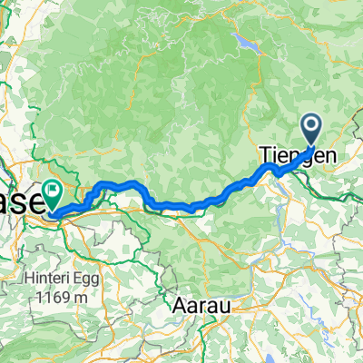
Hauptstraße, Waldshut-Tiengen nach Markgrafenstraße, Lörrach
A cycling route starting in Lauchringen, Baden-Wurttemberg, Germany.
Overview
About this route
- 4 h 13 min
- Duration
- 69.7 km
- Distance
- 594 m
- Ascent
- 630 m
- Descent
- 16.5 km/h
- Avg. speed
- 463 m
- Max. altitude
Route quality
Waytypes & surfaces along the route
Waytypes
Quiet road
33.4 km
(48 %)
Path
19.5 km
(28 %)
Surfaces
Paved
60.6 km
(87 %)
Unpaved
5.6 km
(8 %)
Asphalt
59.9 km
(86 %)
Gravel
5.6 km
(8 %)
Continue with Bikemap
Use, edit, or download this cycling route
You would like to ride Hauptstraße, Waldshut-Tiengen nach Markgrafenstraße, Lörrach or customize it for your own trip? Here is what you can do with this Bikemap route:
Free features
- Save this route as favorite or in collections
- Copy & plan your own version of this route
- Sync your route with Garmin or Wahoo
Premium features
Free trial for 3 days, or one-time payment. More about Bikemap Premium.
- Navigate this route on iOS & Android
- Export a GPX / KML file of this route
- Create your custom printout (try it for free)
- Download this route for offline navigation
Discover more Premium features.
Get Bikemap PremiumFrom our community
Other popular routes starting in Lauchringen
 Lauchringen - Wangen b. Olten
- Distance
- 70.8 km
- Ascent
- 489 m
- Descent
- 442 m
- Location
- Lauchringen, Baden-Wurttemberg, Germany
 Schweiz-Blick Runde
- Distance
- 10.9 km
- Ascent
- 226 m
- Descent
- 214 m
- Location
- Lauchringen, Baden-Wurttemberg, Germany
 Lauchringen - Olten
- Distance
- 68.4 km
- Ascent
- 476 m
- Descent
- 446 m
- Location
- Lauchringen, Baden-Wurttemberg, Germany
 Schweiz Rhein Deutschland
- Distance
- 27.2 km
- Ascent
- 99 m
- Descent
- 99 m
- Location
- Lauchringen, Baden-Wurttemberg, Germany
 Schaffhauser Straße, Waldshut-Tiengen to Schönbeinstrasse, Basel
- Distance
- 79 km
- Ascent
- 458 m
- Descent
- 525 m
- Location
- Lauchringen, Baden-Wurttemberg, Germany
 Abendrunde rund um Tiengen
- Distance
- 25.6 km
- Ascent
- 650 m
- Descent
- 650 m
- Location
- Lauchringen, Baden-Wurttemberg, Germany
 Koblenz AG - Mülhausen
- Distance
- 64.5 km
- Ascent
- 312 m
- Descent
- 521 m
- Location
- Lauchringen, Baden-Wurttemberg, Germany
 Hochrhein Fluss aufwärts. zurück durch die Schweiz
- Distance
- 25.8 km
- Ascent
- 54 m
- Descent
- 57 m
- Location
- Lauchringen, Baden-Wurttemberg, Germany
Open it in the app