

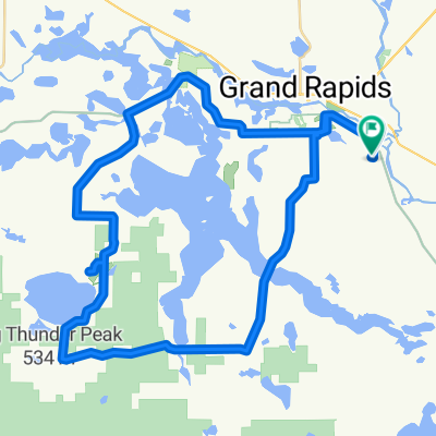
After work ride
A cycling route starting in Grand Rapids, Minnesota, United States.
Overview
About this route
nice ride for hot days around lake after hard day on job
- -:--
- Duration
- 66.4 km
- Distance
- 171 m
- Ascent
- 171 m
- Descent
- ---
- Avg. speed
- ---
- Max. altitude
Route quality
Waytypes & surfaces along the route
Waytypes
Road
60.5 km
(91 %)
Cycleway
3.3 km
(5 %)
Surfaces
Paved
8 km
(12 %)
Paved (undefined)
8 km
(12 %)
Undefined
58.5 km
(88 %)
Continue with Bikemap
Use, edit, or download this cycling route
You would like to ride After work ride or customize it for your own trip? Here is what you can do with this Bikemap route:
Free features
- Save this route as favorite or in collections
- Copy & plan your own version of this route
- Sync your route with Garmin or Wahoo
Premium features
Free trial for 3 days, or one-time payment. More about Bikemap Premium.
- Navigate this route on iOS & Android
- Export a GPX / KML file of this route
- Create your custom printout (try it for free)
- Download this route for offline navigation
Discover more Premium features.
Get Bikemap PremiumFrom our community
Other popular routes starting in Grand Rapids
 U.S. Route 2 680, Grand Rapids to Mesabi Trail, Eveleth
- Distance
- 125.1 km
- Ascent
- 967 m
- Descent
- 874 m
- Location
- Grand Rapids, Minnesota, United States
 After work ride
- Distance
- 66.4 km
- Ascent
- 171 m
- Descent
- 171 m
- Location
- Grand Rapids, Minnesota, United States
 West Grand Rapids then north hwy 65
- Distance
- 164.8 km
- Ascent
- 207 m
- Descent
- 196 m
- Location
- Grand Rapids, Minnesota, United States
 Crystal Springs Road 33170, Grand Rapids to Airport Road 21998, Grand Rapids
- Distance
- 7.2 km
- Ascent
- 42 m
- Descent
- 16 m
- Location
- Grand Rapids, Minnesota, United States
 Great River Energy Mesabi Trail Ride
- Distance
- 114.4 km
- Ascent
- 280 m
- Descent
- 236 m
- Location
- Grand Rapids, Minnesota, United States
 Crystal Springs Road 33136, Grand Rapids to Crystal Springs Road 33136, Grand Rapids
- Distance
- 60.6 km
- Ascent
- 276 m
- Descent
- 271 m
- Location
- Grand Rapids, Minnesota, United States
 Around Pokegama Lake
- Distance
- 54.3 km
- Ascent
- 235 m
- Descent
- 233 m
- Location
- Grand Rapids, Minnesota, United States
 After work ride
- Distance
- 45.8 km
- Ascent
- 178 m
- Descent
- 176 m
- Location
- Grand Rapids, Minnesota, United States
Open it in the app