

Route du Simplon, St-Léonard nach Chemin de Chantegrive, Siders
A cycling route starting in Saint-Léonard, Valais, Switzerland.
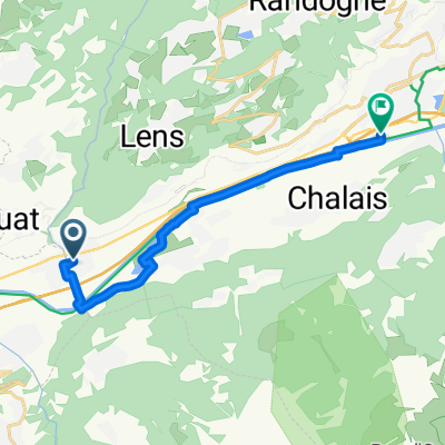
Overview
About this route
Embark on an exhilarating cycling adventure through this scenic route, perfect for those seeking a blend of challenge and beauty. Spanning 12.7 kilometers, the trail offers a delightful ascent of 46 meters and a smooth descent of 29 meters. As you pedal along, you'll reach a maximum elevation of 531 meters, providing breathtaking views and a satisfying sense of accomplishment. The surface is mostly paved, ensuring a smooth ride, with a touch of unpaved paths adding an extra layer of excitement. Whether you're a seasoned cyclist or just looking for a fun ride, this route promises an unforgettable experience.
- 2 h 21 min
- Duration
- 12.7 km
- Distance
- 46 m
- Ascent
- 30 m
- Descent
- 5.4 km/h
- Avg. speed
- 532 m
- Max. altitude

Route quality
Waytypes & surfaces along the route
Waytypes
Track
5.3 km
(42 %)
Road
2.9 km
(23 %)
Surfaces
Paved
7.8 km
(61 %)
Unpaved
0.6 km
(5 %)
Asphalt
7.6 km
(60 %)
Unpaved (undefined)
0.4 km
(3 %)
Continue with Bikemap
Use, edit, or download this cycling route
You would like to ride Route du Simplon, St-Léonard nach Chemin de Chantegrive, Siders or customize it for your own trip? Here is what you can do with this Bikemap route:
Free features
- Save this route as favorite or in collections
- Copy & plan your own version of this route
- Sync your route with Garmin or Wahoo
Premium features
Free trial for 3 days, or one-time payment. More about Bikemap Premium.
- Navigate this route on iOS & Android
- Export a GPX / KML file of this route
- Create your custom printout (try it for free)
- Download this route for offline navigation
Discover more Premium features.
Get Bikemap PremiumFrom our community
Other popular routes starting in Saint-Léonard
 De Rue des Sables 1c, Saint-Léonard a Route de la Californie 2, Saint-Léonard
- Distance
- 38.4 km
- Ascent
- 292 m
- Descent
- 289 m
- Location
- Saint-Léonard, Valais, Switzerland
 Day 2 : Sion to Interlaken via Sanetsch and Jaun
- Distance
- 138.8 km
- Ascent
- 4,268 m
- Descent
- 4,205 m
- Location
- Saint-Léonard, Valais, Switzerland
 CH Wallis 2: Sitten (Hotel Des Vignes) - Aigle (Gare)
- Distance
- 64.4 km
- Ascent
- 271 m
- Descent
- 369 m
- Location
- Saint-Léonard, Valais, Switzerland
 Route du Simplon, St-Léonard nach Chemin de Chantegrive, Siders
- Distance
- 12.7 km
- Ascent
- 46 m
- Descent
- 30 m
- Location
- Saint-Léonard, Valais, Switzerland
 Uvrier - Nax - Dixence
- Distance
- 73.5 km
- Ascent
- 1,473 m
- Descent
- 1,474 m
- Location
- Saint-Léonard, Valais, Switzerland
 Saint Léonard Sion Saint Léonard
- Distance
- 16 km
- Ascent
- 285 m
- Descent
- 284 m
- Location
- Saint-Léonard, Valais, Switzerland
 Bramois à Chemin des Amandiers 53, Sion
- Distance
- 14.8 km
- Ascent
- 182 m
- Descent
- 142 m
- Location
- Saint-Léonard, Valais, Switzerland
 CH: Sion - Crans Montana
- Distance
- 51.9 km
- Ascent
- 1,227 m
- Descent
- 1,208 m
- Location
- Saint-Léonard, Valais, Switzerland
Open it in the app