
Elsterradweg von der Quelle bis zur Mündung - der Brückenradweg - Update 01. März 2015 mit Infos zu Neubaustrecken in der Beschreibung und Aktualisierung Ado...
A cycling route starting in Bad Brambach, Saxony, Germany.
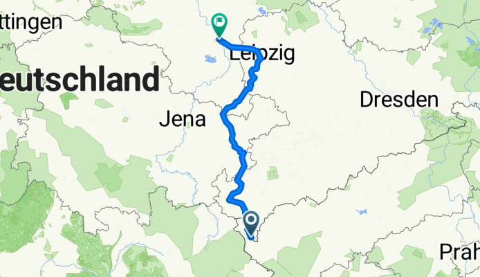
Overview
About this route
Elsterradweg on the wiki here! Recommendation for Elsterquelle-Doubrava for trekking bikes link here! (better surface) Recommendation for Bad Brambach-Elsterquelle link here! 1.3.2015: Hundsgrün-Unterhelmsgrün: new cycle path! 1.11.2014: The reconstruction of the Elsterradweg south of Pegau will follow this alignment. Likely date: 3rd quarter 2015. The road section Trautzschen-Löbnitz-Bennewitz is already completed. The Hundsgrün-Unterhermsgrün section is asphalted on 50% of its length; the rest is a pleasant hiking trail that can be 'ridden' in good weather. See link! Warning: currently not passable due to construction! (March 2015) Bollards and other obstacles here! or directly in the Picasa album. Update 23.7.2013: the current detours can be found on the Elster page on the web. Link: see below! Update 13.7.2013: the new sections planned for 2013 have partly started and could be tested! planned are: - Plauen! - Weischlitz-Pirk - Unterhermsgrün-Bad Elster Update 15.10.2012: the new Elster RW map from Verlag Dr. Barthel makes a very good impression and can also be recommended. Update 5.10.2012: added photo of the Panzerbrücke in Plauen. Tanks from VOMAG were transported over this bridge. - PICASA linked; (images can be deselected under the menu 'More': remove the check) Dr Gebhardt (publisher Grünes Herz Ilmenau; €8.95 with good description, accommodation, etc.) rode the route in 2011 and published an updated Elsterradweg cycle map. The Elsterradweg was inaugurated on 1 May 2004!!
- 16 h 17 min
- Duration
- 256.6 km
- Distance
- 1,761 m
- Ascent
- 2,386 m
- Descent
- 15.8 km/h
- Avg. speed
- 730 m
- Max. altitude

Continue with Bikemap
Use, edit, or download this cycling route
You would like to ride Elsterradweg von der Quelle bis zur Mündung - der Brückenradweg - Update 01. März 2015 mit Infos zu Neubaustrecken in der Beschreibung und Aktualisierung Ado... or customize it for your own trip? Here is what you can do with this Bikemap route:
Free features
- Save this route as favorite or in collections
- Copy & plan your own version of this route
- Split it into stages to create a multi-day tour
- Sync your route with Garmin or Wahoo
Premium features
Free trial for 3 days, or one-time payment. More about Bikemap Premium.
- Navigate this route on iOS & Android
- Export a GPX / KML file of this route
- Create your custom printout (try it for free)
- Download this route for offline navigation
Discover more Premium features.
Get Bikemap PremiumFrom our community
Other popular routes starting in Bad Brambach
 Elster-Radweg
- Distance
- 360.7 km
- Ascent
- 3,045 m
- Descent
- 3,470 m
- Location
- Bad Brambach, Saxony, Germany
 Elsterradweg
- Distance
- 237.5 km
- Ascent
- 1,412 m
- Descent
- 2,022 m
- Location
- Bad Brambach, Saxony, Germany
 Badstraße 45, Bad Brambach nach Badstraße 45, Bad Brambach
- Distance
- 6.2 km
- Ascent
- 69 m
- Descent
- 59 m
- Location
- Bad Brambach, Saxony, Germany
 Schönberg-Skalna-Plesna-Schönberg 21km
- Distance
- 21 km
- Ascent
- 356 m
- Descent
- 351 m
- Location
- Bad Brambach, Saxony, Germany
 Elsterradweg von Bad Brambach über Elsterquelle nach Greiz
- Distance
- 93.4 km
- Ascent
- 574 m
- Descent
- 1,047 m
- Location
- Bad Brambach, Saxony, Germany
 RUD_Tag3_kurz_Raun-Erbenbach
- Distance
- 78.9 km
- Ascent
- 899 m
- Descent
- 915 m
- Location
- Bad Brambach, Saxony, Germany
 W2 2019 Untere Rauner Mühle - Reuth und zurück
- Distance
- 9.8 km
- Ascent
- 259 m
- Descent
- 256 m
- Location
- Bad Brambach, Saxony, Germany
 Elsterquelle
- Distance
- 2 km
- Ascent
- 51 m
- Descent
- 29 m
- Location
- Bad Brambach, Saxony, Germany
Open it in the app