

Garda-Malcesine
A cycling route starting in Garda, Veneto, Italy.
Overview
About this route
MountainBIKE:
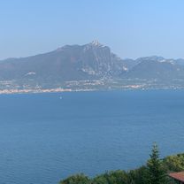
Between Garda and Malcesine runs a special type of panoramic tour. 200 meters above the lakeshore, the route offers rolling terrain on cart paths, through olive groves and old villages. The return to Garda is by boat.
- Length: 30 kilometers
- Elevation gain: 750 meters
Route: Garda – Coi – Crero – Piaghen – Pai – Tronconi – Biasa – Campo – Castello – Sommavilla – Cassone – Malcesine.
Description: Once at altitude, you follow ancient paths to Crero with its panoramic restaurant. After the little church of San Siro, a few meters on the lakeside road await, then it’s time to pedal back up the lost elevation and enjoy the peace in the small villages. The highest point and at the same time the highlight of the tour is the almost abandoned village of Campo.
- -:--
- Duration
- 30 km
- Distance
- 577 m
- Ascent
- 560 m
- Descent
- ---
- Avg. speed
- ---
- Max. altitude
Continue with Bikemap
Use, edit, or download this cycling route
You would like to ride Garda-Malcesine or customize it for your own trip? Here is what you can do with this Bikemap route:
Free features
- Save this route as favorite or in collections
- Copy & plan your own version of this route
- Sync your route with Garmin or Wahoo
Premium features
Free trial for 3 days, or one-time payment. More about Bikemap Premium.
- Navigate this route on iOS & Android
- Export a GPX / KML file of this route
- Create your custom printout (try it for free)
- Download this route for offline navigation
Discover more Premium features.
Get Bikemap PremiumFrom our community
Other popular routes starting in Garda
 Garda nach Mantua
- Distance
- 73.5 km
- Ascent
- 236 m
- Descent
- 323 m
- Location
- Garda, Veneto, Italy
 FamraesMotion1
- Distance
- 88.3 km
- Ascent
- 931 m
- Descent
- 962 m
- Location
- Garda, Veneto, Italy
 Trainingsrunde mit zwei Hügeln
- Distance
- 22.6 km
- Ascent
- 578 m
- Descent
- 578 m
- Location
- Garda, Veneto, Italy
 FamraesMedium4
- Distance
- 113.4 km
- Ascent
- 528 m
- Descent
- 531 m
- Location
- Garda, Veneto, Italy
 MTB Garda Marathon 2015
- Distance
- 59.1 km
- Ascent
- 1,677 m
- Descent
- 1,675 m
- Location
- Garda, Veneto, Italy
 Garda Val Policella
- Distance
- 54 km
- Ascent
- 677 m
- Descent
- 677 m
- Location
- Garda, Veneto, Italy
 Von Garda nach Torri und zurück über Monte Luppia und Monte Are
- Distance
- 25.5 km
- Ascent
- 487 m
- Descent
- 486 m
- Location
- Garda, Veneto, Italy
 FamraesEkspert5
- Distance
- 137.7 km
- Ascent
- 1,356 m
- Descent
- 1,359 m
- Location
- Garda, Veneto, Italy
Open it in the app