
Overview
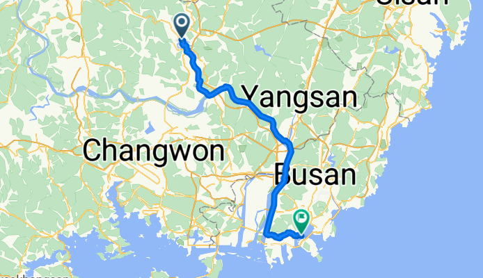
About this route
- 4 h 16 min
- Duration
- 75.8 km
- Distance
- 317 m
- Ascent
- 322 m
- Descent
- 17.8 km/h
- Avg. speed
- 128 m
- Max. altitude
Part of
Seoul - Busan
7 stages
Continue with Bikemap
Use, edit, or download this cycling route
You would like to ride Miryang - Busan or customize it for your own trip? Here is what you can do with this Bikemap route:
Free features
- Save this route as favorite or in collections
- Copy & plan your own version of this route
- Sync your route with Garmin or Wahoo
Premium features
Free trial for 3 days, or one-time payment. More about Bikemap Premium.
- Navigate this route on iOS & Android
- Export a GPX / KML file of this route
- Create your custom printout (try it for free)
- Download this route for offline navigation
Discover more Premium features.
Get Bikemap PremiumFrom our community
Other popular routes starting in Miryang
 Miryang - Busan
- Distance
- 75.8 km
- Ascent
- 317 m
- Descent
- 322 m
- Location
- Miryang, Gyeongsangnam-do, South Korea
 자전거 국토종주(삼랑진-달성)
- Distance
- 101.3 km
- Ascent
- 584 m
- Descent
- 591 m
- Location
- Miryang, Gyeongsangnam-do, South Korea
 밀양역 ~ 물금역
- Distance
- 42 km
- Ascent
- 1,050 m
- Descent
- 1,083 m
- Location
- Miryang, Gyeongsangnam-do, South Korea
 Susan to Busan (D6) River route
- Distance
- 118.4 km
- Ascent
- 419 m
- Descent
- 425 m
- Location
- Miryang, Gyeongsangnam-do, South Korea
 Dzień 7
- Distance
- 54.6 km
- Ascent
- 829 m
- Descent
- 832 m
- Location
- Miryang, Gyeongsangnam-do, South Korea
 상남면 963-6, 밀양시 ~ 상남면 963-5, 밀양시
- Distance
- 24.2 km
- Ascent
- 27 m
- Descent
- 73 m
- Location
- Miryang, Gyeongsangnam-do, South Korea
 밀양 ~ 청도 로드코스
- Distance
- 40.4 km
- Ascent
- 208 m
- Descent
- 175 m
- Location
- Miryang, Gyeongsangnam-do, South Korea
![상남면 963-6, 밀양시Ph0]으로 라우팅](https://media.bikemap.net/routes/15866643/staticmaps/in_539ab1cc-1292-4f9c-bbe0-7d7a8a59bc1d_400x400_bikemap-2021-3D-static.png) 상남면 963-6, 밀양시Ph0]으로 라우팅
상남면 963-6, 밀양시Ph0]으로 라우팅- Distance
- 13.5 km
- Ascent
- 27 m
- Descent
- 68 m
- Location
- Miryang, Gyeongsangnam-do, South Korea
Open it in the app