
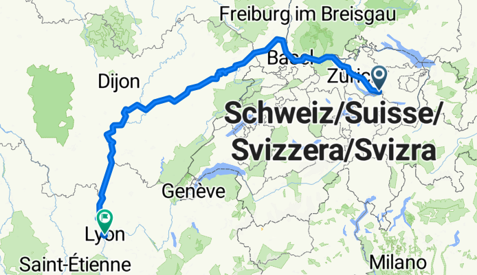
Mythenstrasse, Eschenbach SG nach Place des Terreaux, Lyon
A cycling route starting in Eschenbach, Canton of St. Gallen, Switzerland.
Overview
About this route
Embark on an exhilarating cycling adventure from the charming town of Mythenstrasse 37, Eschenbach SG, to the vibrant city of Lyon, Frankreich. This journey spans a remarkable 627.5 kilometers, offering a diverse terrain that will challenge and delight your senses.
As you set off, prepare to tackle an ascent of 3134 meters and descend 3434 meters, with the highest peak reaching a majestic 545 meters. The surface of your path is a harmonious blend of asphalt and undefined terrain, making for a dynamic ride.
The adventure takes you through various landscapes, including serene paths, tranquil roads, dedicated cycling lanes, and picturesque forest trails. You'll traverse a significant portion of the international bike network, with dedicated paved paths comprising 72.5% of your journey.
Keep your spirits high as you explore both paved and unpaved sections, embracing the thrill of the unknown and the beauty of the natural world. This cycling route promises an unforgettable experience, combining the thrill of exploration with the joy of the open road.
AI generated
- 37 h 36 min
- Duration
- 627.5 km
- Distance
- 3,135 m
- Ascent
- 3,434 m
- Descent
- 16.7 km/h
- Avg. speed
- 546 m
- Max. altitude

Route quality
Waytypes & surfaces along the route
Waytypes
Path
257.3 km
(41 %)
Quiet road
125.5 km
(20 %)
Surfaces
Paved
476.9 km
(76 %)
Unpaved
81.6 km
(13 %)
Asphalt
439.2 km
(70 %)
Gravel
56.5 km
(9 %)
Continue with Bikemap
Use, edit, or download this cycling route
You would like to ride Mythenstrasse, Eschenbach SG nach Place des Terreaux, Lyon or customize it for your own trip? Here is what you can do with this Bikemap route:
Free features
- Save this route as favorite or in collections
- Copy & plan your own version of this route
- Split it into stages to create a multi-day tour
- Sync your route with Garmin or Wahoo
Premium features
Free trial for 3 days, or one-time payment. More about Bikemap Premium.
- Navigate this route on iOS & Android
- Export a GPX / KML file of this route
- Create your custom printout (try it for free)
- Download this route for offline navigation
Discover more Premium features.
Get Bikemap PremiumFrom our community
Other popular routes starting in Eschenbach
 Eschenbach-Fehraltorf übers Ghöch
- Distance
- 42.1 km
- Ascent
- 700 m
- Descent
- 648 m
- Location
- Eschenbach, Canton of St. Gallen, Switzerland
 Klöntaler See
- Distance
- 112.9 km
- Ascent
- 1,794 m
- Descent
- 1,794 m
- Location
- Eschenbach, Canton of St. Gallen, Switzerland
 3 - Route nach Vaduz
- Distance
- 72.9 km
- Ascent
- 975 m
- Descent
- 930 m
- Location
- Eschenbach, Canton of St. Gallen, Switzerland
 105km Zürich See - Ober See Rundfahrt
- Distance
- 104.9 km
- Ascent
- 709 m
- Descent
- 708 m
- Location
- Eschenbach, Canton of St. Gallen, Switzerland
 High-speed route in Pfäffikon SZ
- Distance
- 39.9 km
- Ascent
- 1,592 m
- Descent
- 1,741 m
- Location
- Eschenbach, Canton of St. Gallen, Switzerland
 74km rundt om Eschenbach
- Distance
- 74.3 km
- Ascent
- 1,425 m
- Descent
- 1,423 m
- Location
- Eschenbach, Canton of St. Gallen, Switzerland
 55km Atzmaennig - Ricken - Bachmannsberg
- Distance
- 54.6 km
- Ascent
- 1,232 m
- Descent
- 1,235 m
- Location
- Eschenbach, Canton of St. Gallen, Switzerland
 Eschenbach SG - Leibstadt
- Distance
- 98.6 km
- Ascent
- 799 m
- Descent
- 899 m
- Location
- Eschenbach, Canton of St. Gallen, Switzerland
Open it in the app