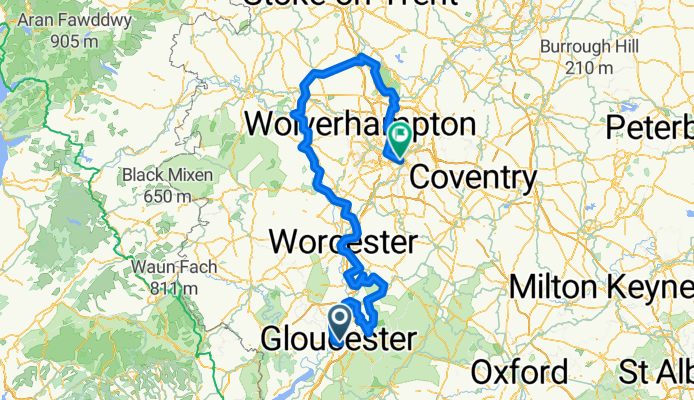
BFCIC26: GLOUCESTER - CHESTER?
A cycling route starting in Gloucester, England, United Kingdom.
Overview
About this route
DAY 1; Glocester - Twks - Cheltenham 27m
DAY 2; Cheltenham - Pershore? - Worcester 47m = 74m
DAY 3; Worcester - Upper Arley - Telford 56m = 130m
DAY 4; Telford - Sttaford - Birmingham 61m = 191m Total
- 20 h 13 min
- Duration
- 306.7 km
- Distance
- 2,189 m
- Ascent
- 2,067 m
- Descent
- 15.2 km/h
- Avg. speed
- 237 m
- Max. altitude
Route quality
Waytypes & surfaces along the route
Waytypes
Quiet road
113.5 km
(37 %)
Cycleway
92 km
(30 %)
Surfaces
Paved
92 km
(30 %)
Unpaved
33.7 km
(11 %)
Asphalt
67.5 km
(22 %)
Paved (undefined)
24.5 km
(8 %)
Route highlights
Points of interest along the route
Point of interest after 62.1 km
Point of interest after 171.9 km
Wocester - Premier Inn
Point of interest after 306.5 km
Telford Premier Inn
Continue with Bikemap
Use, edit, or download this cycling route
You would like to ride BFCIC26: GLOUCESTER - CHESTER? or customize it for your own trip? Here is what you can do with this Bikemap route:
Free features
- Save this route as favorite or in collections
- Copy & plan your own version of this route
- Split it into stages to create a multi-day tour
- Sync your route with Garmin or Wahoo
Premium features
Free trial for 3 days, or one-time payment. More about Bikemap Premium.
- Navigate this route on iOS & Android
- Export a GPX / KML file of this route
- Create your custom printout (try it for free)
- Download this route for offline navigation
Discover more Premium features.
Get Bikemap PremiumFrom our community
Other popular routes starting in Gloucester
- CAD Maisemore 61
- Distance
- 100.7 km
- Ascent
- 692 m
- Descent
- 692 m
- Location
- Gloucester, England, United Kingdom
- Daves 60th birthday 60 mile route
- Distance
- 108.2 km
- Ascent
- 429 m
- Descent
- 426 m
- Location
- Gloucester, England, United Kingdom
- Amanda Day 4 - Gloucester to Nantwich
- Distance
- 166.7 km
- Ascent
- 340 m
- Descent
- 319 m
- Location
- Gloucester, England, United Kingdom
- Severn Farm, Elmore Lane W, Gloucester to Severn Farm, Elmore Lane W, Gloucester
- Distance
- 17.4 km
- Ascent
- 6 m
- Descent
- 7 m
- Location
- Gloucester, England, United Kingdom
- Hartpury Loop
- Distance
- 7.7 km
- Ascent
- 42 m
- Descent
- 38 m
- Location
- Gloucester, England, United Kingdom
- uk-pl 2006
- Distance
- 2,497.4 km
- Ascent
- 3,320 m
- Descent
- 3,176 m
- Location
- Gloucester, England, United Kingdom
- day 10
- Distance
- 103.8 km
- Ascent
- 674 m
- Descent
- 613 m
- Location
- Gloucester, England, United Kingdom
- Steady ride in
- Distance
- 10 km
- Ascent
- 0 m
- Descent
- 3 m
- Location
- Gloucester, England, United Kingdom
Open it in the app