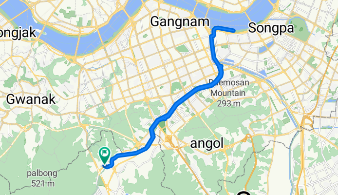
과천동, 과천시에서 양지마을1로, 과천시까지
A cycling route starting in Anyang-si, Gyeonggi-do, South Korea.
Overview
About this route
- 1 h 48 min
- Duration
- 27.1 km
- Distance
- 147 m
- Ascent
- 140 m
- Descent
- 15.1 km/h
- Avg. speed
- 60 m
- Max. altitude
Route photos
Continue with Bikemap
Use, edit, or download this cycling route
You would like to ride 과천동, 과천시에서 양지마을1로, 과천시까지 or customize it for your own trip? Here is what you can do with this Bikemap route:
Free features
- Save this route as favorite or in collections
- Copy & plan your own version of this route
- Sync your route with Garmin or Wahoo
Premium features
Free trial for 3 days, or one-time payment. More about Bikemap Premium.
- Navigate this route on iOS & Android
- Export a GPX / KML file of this route
- Create your custom printout (try it for free)
- Download this route for offline navigation
Discover more Premium features.
Get Bikemap PremiumFrom our community
Other popular routes starting in Anyang-si
- 평촌동 93-11Ph0]으로 라우팅
- Distance
- 102.2 km
- Ascent
- 295 m
- Descent
- 302 m
- Location
- Anyang-si, Gyeonggi-do, South Korea
- 안정적인 라이딩
- Distance
- 47 km
- Ascent
- 215 m
- Descent
- 221 m
- Location
- Anyang-si, Gyeonggi-do, South Korea
- 과천동, 과천시에서 양지마을1로, 과천시까지
- Distance
- 27.1 km
- Ascent
- 147 m
- Descent
- 140 m
- Location
- Anyang-si, Gyeonggi-do, South Korea
- 관양동 1443-2Ph0]으로 라우팅
- Distance
- 14.1 km
- Ascent
- 88 m
- Descent
- 106 m
- Location
- Anyang-si, Gyeonggi-do, South Korea
- 평촌동 61-1 ~ 평촌동 66-18
- Distance
- 86.4 km
- Ascent
- 377 m
- Descent
- 381 m
- Location
- Anyang-si, Gyeonggi-do, South Korea
- 안양 - 소레포구
- Distance
- 33.2 km
- Ascent
- 325 m
- Descent
- 344 m
- Location
- Anyang-si, Gyeonggi-do, South Korea
- 의왕시 - 당산역
- Distance
- 33.9 km
- Ascent
- 119 m
- Descent
- 157 m
- Location
- Anyang-si, Gyeonggi-do, South Korea
- SKV1에서 삼막사 까지
- Distance
- 11.9 km
- Ascent
- 346 m
- Descent
- 77 m
- Location
- Anyang-si, Gyeonggi-do, South Korea
Open it in the app