
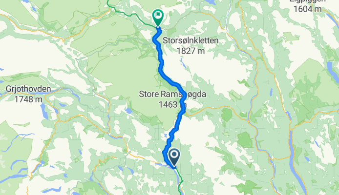
Overview
About this route
- 5 h 45 min
- Duration
- 84.9 km
- Distance
- 1,251 m
- Ascent
- 750 m
- Descent
- 14.8 km/h
- Avg. speed
- 1,059 m
- Max. altitude
Part of
Sommertur Oslo-Trondheim
5 stages
Route quality
Waytypes & surfaces along the route
Waytypes
Cycleway
0.8 km
(1 %)
Undefined
84 km
(99 %)
Surfaces
Paved
1.7 km
(2 %)
Asphalt
1.7 km
(2 %)
Undefined
83.2 km
(98 %)
Continue with Bikemap
Use, edit, or download this cycling route
You would like to ride Dag 3 or customize it for your own trip? Here is what you can do with this Bikemap route:
Free features
- Save this route as favorite or in collections
- Copy & plan your own version of this route
- Split it into stages to create a multi-day tour
- Sync your route with Garmin or Wahoo
Premium features
Free trial for 3 days, or one-time payment. More about Bikemap Premium.
- Navigate this route on iOS & Android
- Export a GPX / KML file of this route
- Create your custom printout (try it for free)
- Download this route for offline navigation
Discover more Premium features.
Get Bikemap PremiumFrom our community
Other popular routes starting in Ringebu
 Ringebu - Skei
- Distance
- 42.9 km
- Ascent
- 942 m
- Descent
- 392 m
- Location
- Ringebu, Oppland, Norway
 Dag 3
Dag 3- Distance
- 84.9 km
- Ascent
- 1,251 m
- Descent
- 750 m
- Location
- Ringebu, Oppland, Norway
 etappe 1 fra Øksendal
- Distance
- 7.9 km
- Ascent
- 294 m
- Descent
- 44 m
- Location
- Ringebu, Oppland, Norway
 Ringebu - Gjøvik (siste)
- Distance
- 111.3 km
- Ascent
- 2,265 m
- Descent
- 2,281 m
- Location
- Ringebu, Oppland, Norway
 Ringebu 1, sjekk veistandard
- Distance
- 48.2 km
- Ascent
- 750 m
- Descent
- 760 m
- Location
- Ringebu, Oppland, Norway
 Frya-Otta
- Distance
- 49.5 km
- Ascent
- 392 m
- Descent
- 289 m
- Location
- Ringebu, Oppland, Norway
 Dag 3
Dag 3- Distance
- 84.8 km
- Ascent
- 1,175 m
- Descent
- 669 m
- Location
- Ringebu, Oppland, Norway
 2005_3 Trondheim_Travemuende
- Distance
- 391.4 km
- Ascent
- 1,266 m
- Descent
- 1,456 m
- Location
- Ringebu, Oppland, Norway
Open it in the app