
Tequila bike | Las Tres Coronas
A cycling route starting in Etzatlán, Jalisco, Mexico.
Overview
About this route
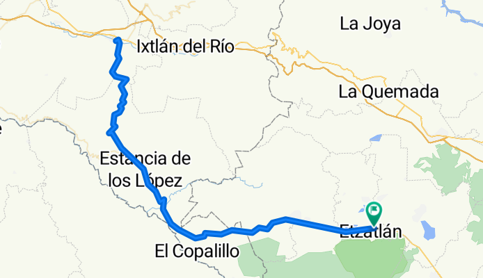
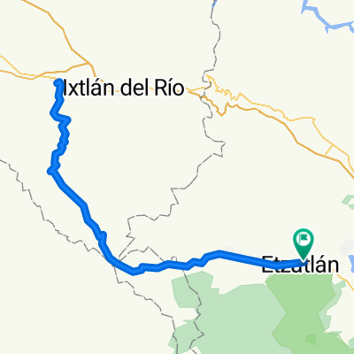
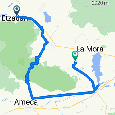
📍ʀᴏᴜᴛᴇ: Etzatlán - Plan de Barrancas - Ahuacatlán - Barranca del Oro - Amatlán de Cañas⏱️ Duration: 6:00 hours🛣️ Distance: 168.5 km⛰️ Elevation: 3,507 meters🥵 Degree of Difficulty: Hardest🔝 Climb: 𝟣ᴘ | 6.4kᴋ | 294ᴍ | 5% | ᴄᴀᴛ. 3🔝 Climb: 2ᴘ | 12.3ᴋ | 763ᴍ | 6% | ᴄᴀᴛ. 1🔝 Climb: 3ᴘ | 7.4ᴋ | 495ᴍ | 7% | ᴄᴀᴛ. 2 🔝 Climb: 4ᴘ | 12ᴋ | 854ᴍ | 7% | HC - 📍ʀᴏᴜᴛᴇ: Etzatlán - Plan de Barrancas - Ahuacatlán - Barranca del Oro - Amatlán de Cañas⏱️ Duration: 6:00 hours🛣️ Distance: 168.5 km⛰️ Elevation: 3,507 meters🥵 Degree of Difficulty: Hardest🔝 Climb: 𝟣ᴘ | 6.4kᴋ | 294ᴍ | 5% | ᴄᴀᴛ. 3🔝 Climb: 2ᴘ | 12.3ᴋ | 763ᴍ | 6% | ᴄᴀᴛ. 1🔝 Climb: 3ᴘ | 7.4ᴋ | 495ᴍ | 7% | ᴄᴀᴛ. 2 🔝 Climb: 4ᴘ | 12ᴋ | 854ᴍ | 7% | HC
- 11 h 47 min
- Duration
- 168.6 km
- Distance
- 3,369 m
- Ascent
- 3,371 m
- Descent
- 14.3 km/h
- Avg. speed
- 1,641 m
- Max. altitude

Continue with Bikemap
Use, edit, or download this cycling route
You would like to ride Tequila bike | Las Tres Coronas or customize it for your own trip? Here is what you can do with this Bikemap route:
Free features
- Save this route as favorite or in collections
- Copy & plan your own version of this route
- Split it into stages to create a multi-day tour
- Sync your route with Garmin or Wahoo
Premium features
Free trial for 3 days, or one-time payment. More about Bikemap Premium.
- Navigate this route on iOS & Android
- Export a GPX / KML file of this route
- Create your custom printout (try it for free)
- Download this route for offline navigation
Discover more Premium features.
Get Bikemap PremiumFrom our community
Other popular routes starting in Etzatlán
 Tequila bike | Las Tres Coronas
- Distance
- 168.6 km
- Ascent
- 3,369 m
- Descent
- 3,371 m
- Location
- Etzatlán, Jalisco, Mexico
 Paseo rápido en Etzatlán
- Distance
- 3.8 km
- Ascent
- 358 m
- Descent
- 113 m
- Location
- Etzatlán, Jalisco, Mexico
 Tequila bike | Vías Verdes
- Distance
- 73.2 km
- Ascent
- 633 m
- Descent
- 747 m
- Location
- Etzatlán, Jalisco, Mexico
 Tequila bike | Circuito del Abuelo
- Distance
- 182.3 km
- Ascent
- 2,701 m
- Descent
- 2,702 m
- Location
- Etzatlán, Jalisco, Mexico
 Avenida Niño Obrero 44, Etzatlán a Calle Jiménez 149, Etzatlán
- Distance
- 33 km
- Ascent
- 223 m
- Descent
- 226 m
- Location
- Etzatlán, Jalisco, Mexico
 Paseo rápido en Etzatlán
- Distance
- 47.5 km
- Ascent
- 1,078 m
- Descent
- 1,085 m
- Location
- Etzatlán, Jalisco, Mexico
 De Colonia Magisterial, Etzatlán a Carolina Cárdenas 569, Etzatlán
- Distance
- 9.1 km
- Ascent
- 68 m
- Descent
- 67 m
- Location
- Etzatlán, Jalisco, Mexico
 Ruta a HYë…?
- Distance
- 23.2 km
- Ascent
- 114 m
- Descent
- 143 m
- Location
- Etzatlán, Jalisco, Mexico
Open it in the app