
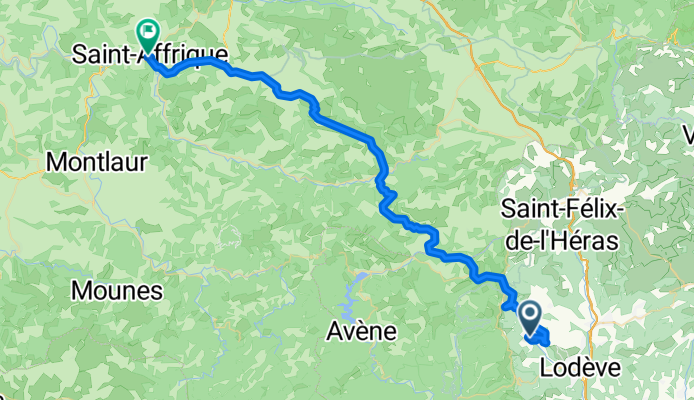
Les Plans (Lodève) to St-Affrique
A cycling route starting in Lodève, Occitanie, France.
Overview
About this route
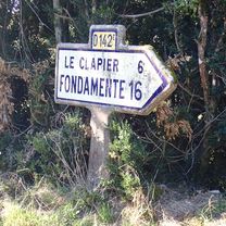
This was a great route on very low traffic roads, except for D999 at the end, which was an arterial that was all downhill with relatively little traffic. We somehow missed a bike path that showed on the map for the last ten kilometers into St-Affrique. If anyone follows this route, they should look for it by Boges road.
The scenery along this route was wonderful. And there's plenty of climbing and descending.
- 6 h 22 min
- Duration
- 57.3 km
- Distance
- 1,126 m
- Ascent
- 1,105 m
- Descent
- 9 km/h
- Avg. speed
- 835 m
- Max. altitude

Route photos
 to St-Affrique\"")
 to St-Affrique\"")
 to St-Affrique\"")
 to St-Affrique\"")
 to St-Affrique\"")
 to St-Affrique\"")
 to St-Affrique\"")
 to St-Affrique\"")
Route quality
Waytypes & surfaces along the route
Waytypes
Road
44.1 km
(77 %)
Quiet road
4.6 km
(8 %)
Surfaces
Paved
19.5 km
(34 %)
Unpaved
0.6 km
(1 %)
Asphalt
19.5 km
(34 %)
Gravel
0.6 km
(1 %)
Undefined
37.2 km
(65 %)
Continue with Bikemap
Use, edit, or download this cycling route
You would like to ride Les Plans (Lodève) to St-Affrique or customize it for your own trip? Here is what you can do with this Bikemap route:
Free features
- Save this route as favorite or in collections
- Copy & plan your own version of this route
- Sync your route with Garmin or Wahoo
Premium features
Free trial for 3 days, or one-time payment. More about Bikemap Premium.
- Navigate this route on iOS & Android
- Export a GPX / KML file of this route
- Create your custom printout (try it for free)
- Download this route for offline navigation
Discover more Premium features.
Get Bikemap PremiumFrom our community
Other popular routes starting in Lodève
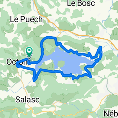
 TdfC 31k Lac Salagou
- Distance
- 30.9 km
- Ascent
- 466 m
- Descent
- 467 m
- Location
- Lodève, Occitanie, France
 Les Plans (Lodève) to St-Affrique
- Distance
- 57.3 km
- Ascent
- 1,126 m
- Descent
- 1,105 m
- Location
- Lodève, Occitanie, France
 Chemin de Ricazouls nach Chemin de Ricazouls
- Distance
- 32.1 km
- Ascent
- 417 m
- Descent
- 448 m
- Location
- Lodève, Occitanie, France
 Lodève to La Loubière, Combret
- Distance
- 89.4 km
- Ascent
- 1,799 m
- Descent
- 1,408 m
- Location
- Lodève, Occitanie, France
 Etape 10 – Du Col de Roube à Dio-et-Valquières
- Distance
- 13.3 km
- Ascent
- 337 m
- Descent
- 384 m
- Location
- Lodève, Occitanie, France
 2021 D 142 Runde bis Mas Gauzin
- Distance
- 11.5 km
- Ascent
- 182 m
- Descent
- 150 m
- Location
- Lodève, Occitanie, France
 Hérault 2010 - 05
- Distance
- 51.1 km
- Ascent
- 910 m
- Descent
- 906 m
- Location
- Lodève, Occitanie, France
 2021 D 493 um La Bastide du Font
- Distance
- 12.4 km
- Ascent
- 177 m
- Descent
- 176 m
- Location
- Lodève, Occitanie, France
Open it in the app