
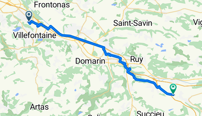
De Lotissement les Cèdres à Chemin d'Ancône
A cycling route starting in La Verpillière, Auvergne-Rhône-Alpes, France.
Overview
About this route
- 2 h 1 min
- Duration
- 25.7 km
- Distance
- 211 m
- Ascent
- 149 m
- Descent
- 12.8 km/h
- Avg. speed
- 341 m
- Max. altitude

Route quality
Waytypes & surfaces along the route
Waytypes
Path
9 km
(35 %)
Quiet road
6.4 km
(25 %)
Surfaces
Paved
16.7 km
(65 %)
Unpaved
5.4 km
(21 %)
Asphalt
16.7 km
(65 %)
Gravel
5.4 km
(21 %)
Undefined
3.6 km
(14 %)
Continue with Bikemap
Use, edit, or download this cycling route
You would like to ride De Lotissement les Cèdres à Chemin d'Ancône or customize it for your own trip? Here is what you can do with this Bikemap route:
Free features
- Save this route as favorite or in collections
- Copy & plan your own version of this route
- Sync your route with Garmin or Wahoo
Premium features
Free trial for 3 days, or one-time payment. More about Bikemap Premium.
- Navigate this route on iOS & Android
- Export a GPX / KML file of this route
- Create your custom printout (try it for free)
- Download this route for offline navigation
Discover more Premium features.
Get Bikemap PremiumFrom our community
Other popular routes starting in La Verpillière
 La Vulpilienne 2018 - 34 km - 19701 - UtagawaVTT.com
- Distance
- 33.1 km
- Ascent
- 607 m
- Descent
- 606 m
- Location
- La Verpillière, Auvergne-Rhône-Alpes, France
 De 21 Impasse de la Foulque, Saint-Quentin-Fallavier à 1–5 Rue des Limouches, Saint-Marcel-lès-Valence
- Distance
- 116.7 km
- Ascent
- 100 m
- Descent
- 247 m
- Location
- La Verpillière, Auvergne-Rhône-Alpes, France
 De Lotissement les Cèdres à Chemin d'Ancône
- Distance
- 25.7 km
- Ascent
- 211 m
- Descent
- 149 m
- Location
- La Verpillière, Auvergne-Rhône-Alpes, France
 La Verpillière - Mâcon
- Distance
- 116.5 km
- Ascent
- 409 m
- Descent
- 459 m
- Location
- La Verpillière, Auvergne-Rhône-Alpes, France
 Rue de Picardie 193, La Verpillière to Impasse des Loipes 150, La Verpillière
- Distance
- 33.6 km
- Ascent
- 791 m
- Descent
- 791 m
- Location
- La Verpillière, Auvergne-Rhône-Alpes, France
 De La Verp à Heyrieux, par le château et le lac - 16382 - UtagawaVTT.com
- Distance
- 29.6 km
- Ascent
- 424 m
- Descent
- 425 m
- Location
- La Verpillière, Auvergne-Rhône-Alpes, France
 Avenue d'Artois naar Route de Moras
- Distance
- 50.5 km
- Ascent
- 715 m
- Descent
- 707 m
- Location
- La Verpillière, Auvergne-Rhône-Alpes, France
 Itinéraire vers 2 Rue de la République, La Verpillière
- Distance
- 0.9 km
- Ascent
- 0 m
- Descent
- 17 m
- Location
- La Verpillière, Auvergne-Rhône-Alpes, France
Open it in the app