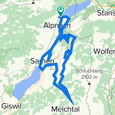
O-Tour 42
A cycling route starting in Alpnach, Canton of Obwalden, Switzerland.
Overview
About this route
- -:--
- Duration
- 45.2 km
- Distance
- 1,613 m
- Ascent
- 1,610 m
- Descent
- ---
- Avg. speed
- ---
- Avg. speed
Continue with Bikemap
Use, edit, or download this cycling route
You would like to ride O-Tour 42 or customize it for your own trip? Here is what you can do with this Bikemap route:
Free features
- Save this route as favorite or in collections
- Copy & plan your own version of this route
- Sync your route with Garmin or Wahoo
Premium features
Free trial for 3 days, or one-time payment. More about Bikemap Premium.
- Navigate this route on iOS & Android
- Export a GPX / KML file of this route
- Create your custom printout (try it for free)
- Download this route for offline navigation
Discover more Premium features.
Get Bikemap PremiumFrom our community
Other popular routes starting in Alpnach
- Rickenmetteln
- Distance
- 30.2 km
- Ascent
- 1,236 m
- Descent
- 1,236 m
- Location
- Alpnach, Canton of Obwalden, Switzerland
- hohoho hahaha
- Distance
- 38.9 km
- Ascent
- 418 m
- Descent
- 418 m
- Location
- Alpnach, Canton of Obwalden, Switzerland
- Aecherli Runde 08.19
- Distance
- 22.5 km
- Ascent
- 669 m
- Descent
- 667 m
- Location
- Alpnach, Canton of Obwalden, Switzerland
- Königstour 2013 Fun
- Distance
- 95 km
- Ascent
- 2,078 m
- Descent
- 2,078 m
- Location
- Alpnach, Canton of Obwalden, Switzerland
- O-Tour 42
- Distance
- 45.2 km
- Ascent
- 1,613 m
- Descent
- 1,610 m
- Location
- Alpnach, Canton of Obwalden, Switzerland
- Entspannende Route in Alpnach-Kerns-Sarnen
- Distance
- 12 km
- Ascent
- 267 m
- Descent
- 240 m
- Location
- Alpnach, Canton of Obwalden, Switzerland
- Markus, OW-Tour 22.10.03
- Distance
- 51.1 km
- Ascent
- 1,339 m
- Descent
- 1,339 m
- Location
- Alpnach, Canton of Obwalden, Switzerland
- Alpnach Wichelsee
- Distance
- 5.9 km
- Ascent
- 56 m
- Descent
- 56 m
- Location
- Alpnach, Canton of Obwalden, Switzerland
Open it in the app