

Wanna be at the white house on the top ;)
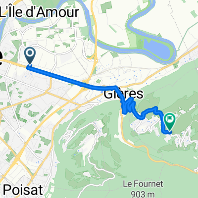
A cycling route starting in Saint-Martin-d'Hères, Auvergne-Rhône-Alpes, France.
Overview
About this route
I saw a white ski house on the top of a mountain, near the city. I live in Hungary with ca. 1000 m highest point nearby, so it was a challange to go up. It was made with a 2005 Banshee Chaparral + 2003 Junior-T - ca. 20.5 kgs. I suggest a lighter bike for going up... ;) But the sigth worths to suffer up! TAKE A LOT OF WATER! I found no source between Uriage and Chamrousse!
- -:--
- Duration
- 27.2 km
- Distance
- 2,013 m
- Ascent
- 22 m
- Descent
- ---
- Avg. speed
- ---
- Max. altitude

Route highlights
Points of interest along the route
\"")
Point of interest after 9.6 km
\"")
Point of interest after 10.8 km
\"")
Point of interest after 10.8 km
\"")
Point of interest after 11.4 km
\"")
Point of interest after 13.1 km
\"")
Point of interest after 14.4 km
Good place to eat :)
\"")
Point of interest after 16.7 km
\"")
Point of interest after 16.9 km
\"")
Point of interest after 16.9 km
\"")
Point of interest after 17 km
\"")
Point of interest after 17.7 km
\"")
Point of interest after 17.7 km
\"")
Point of interest after 17.7 km
\"")
Point of interest after 19.2 km
Was a good feeling to know that it goes up 370 m on 2,6 Km
\"")
Point of interest after 19.2 km
A guy didn't drift it with an MX-5.... BAAAAAD :D
\"")
Point of interest after 20.2 km
\"")
Point of interest after 20.2 km
\"")
Point of interest after 20.7 km
\"")
Point of interest after 20.7 km
\"")
Point of interest after 21.2 km
\"")
Point of interest after 21.2 km
\"")
Point of interest after 21.6 km
\"")
Point of interest after 23.7 km
First source since Uriage :)
\"")
Point of interest after 24.3 km
There's no much no.... NOT
\"")
Point of interest after 25.4 km
\"")
Point of interest after 25.8 km
\"")
Point of interest after 26.4 km
\"")
Point of interest after 26.5 km
\"")
Point of interest after 26.6 km
\"")
Point of interest after 26.8 km
\"")
Point of interest after 27.1 km
The lift closes, sheeps come :D
\"")
Point of interest after 27.1 km
\"")
Point of interest after 27.1 km
Continue with Bikemap
Use, edit, or download this cycling route
You would like to ride Wanna be at the white house on the top ;) or customize it for your own trip? Here is what you can do with this Bikemap route:
Free features
- Save this route as favorite or in collections
- Copy & plan your own version of this route
- Sync your route with Garmin or Wahoo
Premium features
Free trial for 3 days, or one-time payment. More about Bikemap Premium.
- Navigate this route on iOS & Android
- Export a GPX / KML file of this route
- Create your custom printout (try it for free)
- Download this route for offline navigation
Discover more Premium features.
Get Bikemap PremiumFrom our community
Other popular routes starting in Saint-Martin-d'Hères
 Wanna be at the white house on the top ;)
- Distance
- 27.2 km
- Ascent
- 2,013 m
- Descent
- 22 m
- Location
- Saint-Martin-d'Hères, Auvergne-Rhône-Alpes, France
 Tour Belledonne par Villard-Bonnot
- Distance
- 52.1 km
- Ascent
- 880 m
- Descent
- 878 m
- Location
- Saint-Martin-d'Hères, Auvergne-Rhône-Alpes, France
 Montée Chamrousse depuis Grenoble
- Distance
- 67.1 km
- Ascent
- 1,571 m
- Descent
- 1,571 m
- Location
- Saint-Martin-d'Hères, Auvergne-Rhône-Alpes, France
 Clémencière + Palaquit
- Distance
- 36.8 km
- Ascent
- 1,045 m
- Descent
- 1,045 m
- Location
- Saint-Martin-d'Hères, Auvergne-Rhône-Alpes, France
 venon
venon- Distance
- 5.8 km
- Ascent
- 374 m
- Descent
- 50 m
- Location
- Saint-Martin-d'Hères, Auvergne-Rhône-Alpes, France
 Challange of St. Eynard
- Distance
- 33.3 km
- Ascent
- 1,185 m
- Descent
- 1,186 m
- Location
- Saint-Martin-d'Hères, Auvergne-Rhône-Alpes, France
 Grand tour Chartreuse depuis Grenoble
- Distance
- 71.8 km
- Ascent
- 1,318 m
- Descent
- 1,318 m
- Location
- Saint-Martin-d'Hères, Auvergne-Rhône-Alpes, France
 Grenoble Kyriad - Alpe d'Huez
- Distance
- 58.9 km
- Ascent
- 1,812 m
- Descent
- 259 m
- Location
- Saint-Martin-d'Hères, Auvergne-Rhône-Alpes, France
Open it in the app