
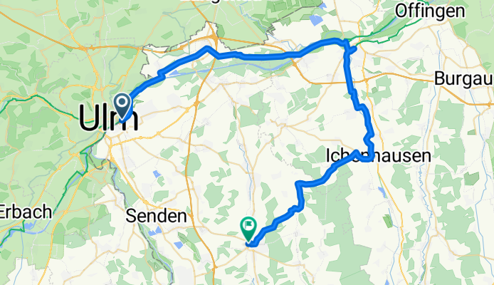
ULM-26-E3-Günzburg-Weißenhorn
A cycling route starting in Neu-Ulm, Bavaria, Germany.
Overview
About this route
- 3 h 23 min
- Duration
- 53.9 km
- Distance
- 248 m
- Ascent
- 223 m
- Descent
- 15.9 km/h
- Avg. speed
- 542 m
- Max. altitude

Route quality
Waytypes & surfaces along the route
Waytypes
Path
16.2 km
(30 %)
Track
14 km
(26 %)
Surfaces
Paved
37.8 km
(70 %)
Unpaved
13.5 km
(25 %)
Asphalt
35.6 km
(66 %)
Gravel
13.5 km
(25 %)
Continue with Bikemap
Use, edit, or download this cycling route
You would like to ride ULM-26-E3-Günzburg-Weißenhorn or customize it for your own trip? Here is what you can do with this Bikemap route:
Free features
- Save this route as favorite or in collections
- Copy & plan your own version of this route
- Sync your route with Garmin or Wahoo
Premium features
Free trial for 3 days, or one-time payment. More about Bikemap Premium.
- Navigate this route on iOS & Android
- Export a GPX / KML file of this route
- Create your custom printout (try it for free)
- Download this route for offline navigation
Discover more Premium features.
Get Bikemap PremiumFrom our community
Other popular routes starting in Neu-Ulm
 BRT2012-MI: Drei-Täler-Tour - RTF des BRT2012 in Ulm - 103 km Strecke
- Distance
- 126 km
- Ascent
- 611 m
- Descent
- 610 m
- Location
- Neu-Ulm, Bavaria, Germany
 BRT2012-DO: Zwischen Iller und Rot - RTF des BRT2012 in Ulm - 114 km Strecke
- Distance
- 108.9 km
- Ascent
- 384 m
- Descent
- 384 m
- Location
- Neu-Ulm, Bavaria, Germany
 BRT2012-FR: Über die Alb und entlang des Kliffs - RTF des BRT2012 in Ulm - 72 km Strecke
- Distance
- 68.2 km
- Ascent
- 394 m
- Descent
- 394 m
- Location
- Neu-Ulm, Bavaria, Germany
 ULM-26-E3-Günzburg-Weißenhorn
- Distance
- 53.9 km
- Ascent
- 248 m
- Descent
- 223 m
- Location
- Neu-Ulm, Bavaria, Germany
 BRT2012-FR: Über die Alb und entlang des Kliffs - RTF des BRT2012 in Ulm - 107 km Strecke
- Distance
- 102.8 km
- Ascent
- 525 m
- Descent
- 525 m
- Location
- Neu-Ulm, Bavaria, Germany
 BRT2012-FR: Über die Alb und entlang des Kliffs - RTF des BRT2012 in Ulm - 42 km Strecke
- Distance
- 39.8 km
- Ascent
- 274 m
- Descent
- 274 m
- Location
- Neu-Ulm, Bavaria, Germany
 BRT2012-MI: Drei-Täler-Tour - RTF des BRT2012 in Ulm - 72 km Strecke
- Distance
- 87.9 km
- Ascent
- 567 m
- Descent
- 567 m
- Location
- Neu-Ulm, Bavaria, Germany
 Max-Eyth-Straße 351/2 nach St2029
- Distance
- 78.4 km
- Ascent
- 476 m
- Descent
- 474 m
- Location
- Neu-Ulm, Bavaria, Germany
Open it in the app