
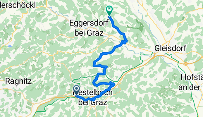
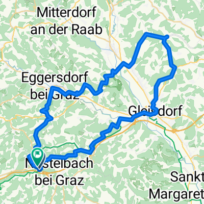
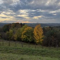
Hauptstraße, Laßnitzhöhe nach Wetterkreuzweg, Eggersdorf
A cycling route starting in Nestelbach bei Graz, Styria, Austria.
Overview
About this route
Embark on a thrilling cycling adventure along this scenic route, stretching over 20.6 km with a gentle mix of ascents and descents. Feel the rush as you conquer a 358-meter climb and then descend 351 meters, all while reaching a maximum elevation of 516 meters. This dynamic journey offers a perfect balance of challenge and beauty, ideal for riders seeking an invigorating yet manageable ride.
AI generated
- 1 h 3 min
- Duration
- 20.6 km
- Distance
- 358 m
- Ascent
- 352 m
- Descent
- 19.6 km/h
- Avg. speed
- 516 m
- Max. altitude

Route photos


Route quality
Waytypes & surfaces along the route
Waytypes
Quiet road
11.5 km
(56 %)
Road
7.6 km
(37 %)
Surfaces
Paved
12.6 km
(61 %)
Asphalt
12.4 km
(60 %)
Concrete
0.2 km
(1 %)
Undefined
8 km
(39 %)
Continue with Bikemap
Use, edit, or download this cycling route
You would like to ride Hauptstraße, Laßnitzhöhe nach Wetterkreuzweg, Eggersdorf or customize it for your own trip? Here is what you can do with this Bikemap route:
Free features
- Save this route as favorite or in collections
- Copy & plan your own version of this route
- Sync your route with Garmin or Wahoo
Premium features
Free trial for 3 days, or one-time payment. More about Bikemap Premium.
- Navigate this route on iOS & Android
- Export a GPX / KML file of this route
- Create your custom printout (try it for free)
- Download this route for offline navigation
Discover more Premium features.
Get Bikemap PremiumFrom our community
Other popular routes starting in Nestelbach bei Graz
 Moggau, Laßnitzhöhe nach Hauptstraße, Laßnitzhöhe
- Distance
- 18.5 km
- Ascent
- 361 m
- Descent
- 372 m
- Location
- Nestelbach bei Graz, Styria, Austria
 Lanitzthal - St. Margarethen - Laßnitzhöhe
- Distance
- 40.4 km
- Ascent
- 256 m
- Descent
- 256 m
- Location
- Nestelbach bei Graz, Styria, Austria
 Apfelandtour
- Distance
- 60.2 km
- Ascent
- 529 m
- Descent
- 521 m
- Location
- Nestelbach bei Graz, Styria, Austria
 verlängerte Höf-Präbach & Lebring Tour CLONED FROM ROUTE 455521
- Distance
- 89.9 km
- Ascent
- 0 m
- Descent
- 0 m
- Location
- Nestelbach bei Graz, Styria, Austria
 Moggau, Laßnitzhöhe nach Moggau, Laßnitzhöhe
- Distance
- 47.1 km
- Ascent
- 1,002 m
- Descent
- 1,002 m
- Location
- Nestelbach bei Graz, Styria, Austria
 Hauptstraße, Laßnitzhöhe nach Wetterkreuzweg, Eggersdorf
- Distance
- 20.6 km
- Ascent
- 358 m
- Descent
- 352 m
- Location
- Nestelbach bei Graz, Styria, Austria
 Laßnitzhöhe-Graz Etappe 8
- Distance
- 16.5 km
- Ascent
- 112 m
- Descent
- 232 m
- Location
- Nestelbach bei Graz, Styria, Austria
 Hauptstraße, Laßnitzhöhe nach Hauptstraße, Laßnitzhöhe
- Distance
- 24.4 km
- Ascent
- 573 m
- Descent
- 577 m
- Location
- Nestelbach bei Graz, Styria, Austria
Open it in the app