

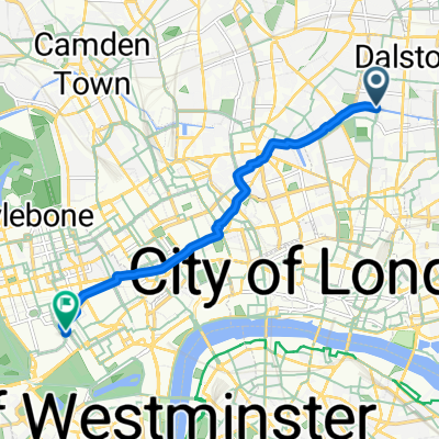
40 Islington High Street, London to 2 1/2 Camden Park Road, London
A cycling route starting in Islington, England, United Kingdom.
Overview
About this route
- 15 min
- Duration
- 2.5 km
- Distance
- 38 m
- Ascent
- 28 m
- Descent
- 10.2 km/h
- Avg. speed
- 48 m
- Max. altitude

Route photos

Route quality
Waytypes & surfaces along the route
Waytypes
Road
0.5 km
(20 %)
Cycleway
0.5 km
(20 %)
Surfaces
Paved
2.4 km
(95 %)
Asphalt
2.3 km
(92 %)
Paved (undefined)
0.1 km
(3 %)
Undefined
0.1 km
(5 %)
Continue with Bikemap
Use, edit, or download this cycling route
You would like to ride 40 Islington High Street, London to 2 1/2 Camden Park Road, London or customize it for your own trip? Here is what you can do with this Bikemap route:
Free features
- Save this route as favorite or in collections
- Copy & plan your own version of this route
- Sync your route with Garmin or Wahoo
Premium features
Free trial for 3 days, or one-time payment. More about Bikemap Premium.
- Navigate this route on iOS & Android
- Export a GPX / KML file of this route
- Create your custom printout (try it for free)
- Download this route for offline navigation
Discover more Premium features.
Get Bikemap PremiumFrom our community
Other popular routes starting in Islington
 raygrenn2
- Distance
- 32.3 km
- Ascent
- 22 m
- Descent
- 4 m
- Location
- Islington, England, United Kingdom
 40 Islington High Street, London to 2 1/2 Camden Park Road, London
- Distance
- 2.5 km
- Ascent
- 38 m
- Descent
- 28 m
- Location
- Islington, England, United Kingdom
 Giant northern loop
- Distance
- 91.6 km
- Ascent
- 451 m
- Descent
- 450 m
- Location
- Islington, England, United Kingdom
 Route to Saint Pancras International
- Distance
- 4.6 km
- Ascent
- 25 m
- Descent
- 22 m
- Location
- Islington, England, United Kingdom
 Belvedere Court, London to Curzon Street, London
- Distance
- 6.8 km
- Ascent
- 35 m
- Descent
- 40 m
- Location
- Islington, England, United Kingdom
 Rosemary Branch Haggerston return via Q11
- Distance
- 8.8 km
- Ascent
- 44 m
- Descent
- 56 m
- Location
- Islington, England, United Kingdom
 Political Waters in Ilinghton and Hackney
- Distance
- 15.4 km
- Ascent
- 51 m
- Descent
- 49 m
- Location
- Islington, England, United Kingdom
 Popham Road, London to Handyside Street, London
- Distance
- 3.8 km
- Ascent
- 21 m
- Descent
- 43 m
- Location
- Islington, England, United Kingdom
Open it in the app