
Von München zum Gardasee - Track
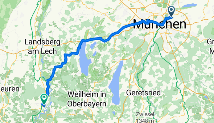
Tag 1: Von München nach Schongau
A cycling route starting in Unterföhring, Bavaria, Germany.
Overview
About this route
- 5 h 56 min
- Duration
- 98.5 km
- Distance
- 744 m
- Ascent
- 599 m
- Descent
- 16.6 km/h
- Avg. speed
- 741 m
- Max. altitude
Part of
Von München zum Gardasee - Track
6 stages
Route quality
Waytypes & surfaces along the route
Waytypes
Quiet road
2 km
(2 %)
Road
1 km
(1 %)
Undefined
95.6 km
(97 %)
Surfaces
Paved
3 km
(3 %)
Asphalt
3 km
(3 %)
Undefined
95.6 km
(97 %)
Continue with Bikemap
Use, edit, or download this cycling route
You would like to ride Tag 1: Von München nach Schongau or customize it for your own trip? Here is what you can do with this Bikemap route:
Free features
- Save this route as favorite or in collections
- Copy & plan your own version of this route
- Split it into stages to create a multi-day tour
- Sync your route with Garmin or Wahoo
Premium features
Free trial for 3 days, or one-time payment. More about Bikemap Premium.
- Navigate this route on iOS & Android
- Export a GPX / KML file of this route
- Create your custom printout (try it for free)
- Download this route for offline navigation
Discover more Premium features.
Get Bikemap PremiumFrom our community
Other popular routes starting in Unterföhring
 Abendausflug zum Hypoberg
- Distance
- 6.7 km
- Ascent
- 58 m
- Descent
- 92 m
- Location
- Unterföhring, Bavaria, Germany
 Münchner Straße, Unterföhring nach Isargestade, Landshut
- Distance
- 75.9 km
- Ascent
- 156 m
- Descent
- 276 m
- Location
- Unterföhring, Bavaria, Germany
 Zum Apple Workshop durch den Englischen Garten Tag 1
- Distance
- 9.3 km
- Ascent
- 29 m
- Descent
- 26 m
- Location
- Unterföhring, Bavaria, Germany
 Runde am Wasser
- Distance
- 33.3 km
- Ascent
- 49 m
- Descent
- 50 m
- Location
- Unterföhring, Bavaria, Germany
 OK12 - P12
- Distance
- 8.4 km
- Ascent
- 31 m
- Descent
- 12 m
- Location
- Unterföhring, Bavaria, Germany
 Rundkurs Unterföhring-Haar
- Distance
- 31.8 km
- Ascent
- 42 m
- Descent
- 42 m
- Location
- Unterföhring, Bavaria, Germany
 München (City-Parktour 3)
- Distance
- 34.9 km
- Ascent
- 54 m
- Descent
- 54 m
- Location
- Unterföhring, Bavaria, Germany
 Isarradweg
- Distance
- 19.6 km
- Ascent
- 63 m
- Descent
- 113 m
- Location
- Unterföhring, Bavaria, Germany
Open it in the app